
Сделать пожертвование
Топографическая карта Hoher Dachstein
Нажмите на карту, чтобы отобразить высоту.
Сделать пожертвование
Hoher Dachstein
The Dachstein massif covers an area of around 600 square kilometres (230 sq mi) with dozens of peaks above 2,500 m, the highest of which are in the southern and southwestern areas. The main summit of the Hoher Dachstein is at an elevation of 2,997 metres (9,833 ft). Seen from the north, the Dachstein massif is dominated by glaciers with rocky summits rising beyond them. By contrast, to the south, the mountain drops almost vertically to the valley floor.
Сделать пожертвование
Об этой карте
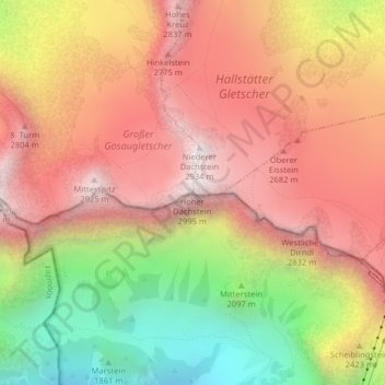
Название: Топографическая карта Hoher Dachstein, высота, рельеф.
Местонахождение: Hoher Dachstein, Gosau, Politische Expositur Gröbming, Bezirk Gmunden, Upper Austria, 4824, Austria (47.47514 13.60562 47.47524 13.60572)
Средняя высота: 2 341 м
Минимальная высота: 1 579 м
Максимальная высота: 2 903 м
Сделать пожертвование