
Топографическая карта Bloomington
Интерактивная карта
Нажмите на карту, чтобы отобразить высоту.
Об этой карте
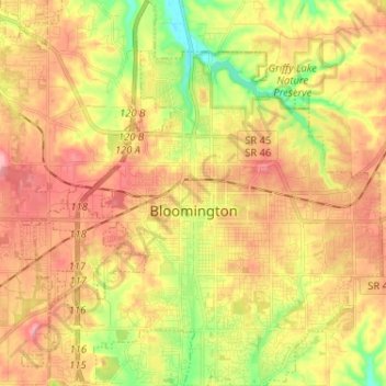
Название: Топографическая карта Bloomington, высота, рельеф.
Местонахождение: Bloomington, Monroe County, Indiana, United States (39.12133 -86.59189 39.22136 -86.47113)
Средняя высота: 241 м
Минимальная высота: 177 м
Максимальная высота: 293 м
Bloomington is an area of irregular limestone terrain characterized by sinks, ravines, fissures, underground streams, sinking streams, springs and caves. It is in the rolling hills of southern Indiana, resting on the intersection of the Norman Uplands and the Mitchell Plain. The city's relatively varied topography is a sharp contrast to the flatter terrain more typical of central to northern portions of Indiana.
Другие топографические карты
Нажмите на карту, чтобы просмотреть ее топографию, ее высоту и ее рельеф.
Clear Creek
United States > Indiana > Monroe County > Clear Creek
Clear Creek, Monroe County, Indiana, United States
Средняя высота: 218 м
University Lake Dam
United States > Indiana > Monroe County > Bloomington
University Lake Dam, Bloomington, Monroe County, Indiana, 47408, United States
Средняя высота: 236 м
Upper Cascades Park
United States > Indiana > Monroe County > Bloomington
Upper Cascades Park, Bloomington, Monroe County, Indiana, United States
Средняя высота: 217 м
Ellettsville
United States > Indiana > Monroe County
Ellettsville, Monroe County, Indiana, United States
Средняя высота: 235 м
Broadview
United States > Indiana > Monroe County > Bloomington
Broadview, Bloomington, Monroe County, Indiana, 47402, United States
Средняя высота: 231 м