
Сделать пожертвование
Топографическая карта North Paravur
Нажмите на карту, чтобы отобразить высоту.
Сделать пожертвование
North Paravur
Paravur is located at 10.14° N 76.7° E[1]. It has an average elevation of 10 metres (32 feet). The town is situated at north end of Ernakulam district and bordering with Thrissur district. The towns in Thrissur district like Kodungallore, Mala, Chalakudy and the towns Kalamassery, Aluva, Angamaly, Vypin island are located near to this town. The Paravur Taluk lies in the flat delta region of the Periyar river and cut by several canals, which have resulted in the formation of many islands. The Kodungalloor Kayal (backwaters) and Varappuzha Kayal (backwaters) are in this taluk. The town and neighboring areas were deeply affected by floods in 2018 due to heavy rain.
Сделать пожертвование
Об этой карте
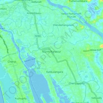
Название: Топографическая карта North Paravur, высота, рельеф.
Местонахождение: North Paravur, Paravur, Ernakulam, Kerala, 683513, India (10.10841 76.18492 10.18841 76.26492)
Средняя высота: 5 м
Минимальная высота: -3 м
Максимальная высота: 23 м
Сделать пожертвование
Другие топографические карты
Нажмите на карту, чтобы просмотреть ее топографию, ее высоту и ее рельеф.
Сделать пожертвование
periyar river
India > Kerala > Paravur > Manjaly
The southernmost part of the Cardamom Hills i.e. the source of Periyar River is a narrow valley extending south of Kumily. This is the southern extreme of the Periyar basin. It is less than 20 kilometres (12 mi) wide and is about 40 kilometres (25 mi) long. The upper catchments of Periyar extend as a wedge…
Средняя высота: 10 м
Periyar River
India > Kerala > Paravur > Edayar
The southernmost part of the Cardamom Hills i.e. the source of Periyar River is a narrow valley extending south of Kumily. This is the southern extreme of the Periyar basin. It is less than 20 kilometres (12 mi) wide and is about 40 kilometres (25 mi) long. The upper catchments of Periyar extend as a wedge…
Средняя высота: 8 м
Сделать пожертвование