
Сделать пожертвование
Топографическая карта Ipswich
Нажмите на карту, чтобы отобразить высоту.
Сделать пожертвование
Ipswich
Ipswich experiences an oceanic climate, like the rest of the British Isles, with a narrow range of temperature and rainfall spread evenly throughout the year. One of the two nearest for which data is available is East Bergholt, about 7 miles (11 km) south west of the town centre and at a similar elevation, and similar river valley/estuary situation. The average July maximum of 23.2 °C (73.8 °F) is the third-highest for a major settlement in the country, behind London and Colchester, illustrating the relative warmth of the area during the summer part of the year. The record maximum is 35.2 °C (95.4 °F), set during August 2003. Typically, 24.9 days of the year will record a maximum temperature of 25.1 °C (77.2 °F) or above, and the warmest day of the year should reach 30.0 °C (86.0 °F), on average.
Сделать пожертвование
Об этой карте
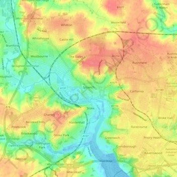
Название: Топографическая карта Ipswich, высота, рельеф.
Местонахождение: Ipswich, Suffolk, England, United Kingdom (52.02016 1.10725 52.09445 1.22365)
Средняя высота: 29 м
Минимальная высота: -3 м
Максимальная высота: 56 м
Сделать пожертвование
Другие топографические карты
Нажмите на карту, чтобы просмотреть ее топографию, ее высоту и ее рельеф.
Gunton Sands
United Kingdom > England > Suffolk > East Suffolk > Lowestoft > Corton
Средняя высота: 10 м
Constable 'The Haywain' viewing point
United Kingdom > England > Suffolk > Babergh > East Bergholt > Flatford
Средняя высота: 15 м
Сделать пожертвование
Сделать пожертвование
Сделать пожертвование
Сделать пожертвование
Сделать пожертвование
Сделать пожертвование
Walton
United Kingdom > England > Suffolk > Felixstowe
Walton Hall was built in c.1740–1750 and rebuilt and extended in c.1799 as evidenced by a date stone which is initialled for the contemporary owner Anthony Collett. The building has been known as Walton Hall from c.1813 when the original manorial complex which lay in Walton Village to the east was…
Средняя высота: 12 м
Сделать пожертвование
Sutton Hoo Archeological Site
United Kingdom > England > Suffolk > East Suffolk > Sutton
Средняя высота: 19 м
Сделать пожертвование
Сделать пожертвование
Lowestoft Inner Harbour
United Kingdom > England > Suffolk > East Suffolk > Lowestoft > Oulton Broad
Средняя высота: 8 м
Сделать пожертвование
Site of old Orfordness Lighthouse
United Kingdom > England > Suffolk > East Suffolk > Orford
Средняя высота: 0 м
Сделать пожертвование
Rendlesham UFO Landing Site #2
United Kingdom > England > Suffolk > East Suffolk > Butley Abbey
Средняя высота: 14 м
Сделать пожертвование
Haughley Park
United Kingdom > England > Suffolk > Haughley > Haughley New Street
Средняя высота: 63 м
Сделать пожертвование
Сделать пожертвование
Сделать пожертвование
Сделать пожертвование
Ipswich
United Kingdom > England > Suffolk > Ipswich
Ipswich experiences an oceanic climate, like the rest of the British Isles, with a narrow range of temperature and rainfall spread evenly throughout the year. One of the two nearest for which data is available is East Bergholt, about 7 miles (11 km) south west of the town centre and at a similar elevation, and…
Средняя высота: 30 м
Сделать пожертвование
Long Melford-Bury St Edmunds branch line
United Kingdom > England > Suffolk > Babergh > Lavenham
Средняя высота: 70 м
Thorpe Street
United Kingdom > England > Suffolk > Mid Suffolk > Hinderclay > Thorpe Street
Средняя высота: 36 м
Сделать пожертвование
Mill Green
United Kingdom > England > Suffolk > Babergh > Edwardstone > Mill Green
Средняя высота: 59 м
Withersdale Street
United Kingdom > England > Suffolk > Mid Suffolk > Mendham > Withersdale Street
Средняя высота: 38 м
Lower Green
United Kingdom > England > Suffolk > West Suffolk > Higham > Lower Green
Средняя высота: 67 м
Blackthorpe
United Kingdom > England > Suffolk > West Suffolk > Rougham > Blackthorpe
Средняя высота: 63 м
Сделать пожертвование
Сделать пожертвование
Ipswich
United Kingdom > England > Suffolk > Ipswich
Ipswich experiences an oceanic climate, like the rest of the British Isles, with a narrow range of temperature and rainfall spread evenly throughout the year. One of the two nearest for which data is available is East Bergholt, about 7 miles (11 km) south west of the town centre and at a similar elevation, and…
Средняя высота: 30 м
Сделать пожертвование
Сделать пожертвование
Сделать пожертвование