
Сделать пожертвование
Топографическая карта Godalming
Нажмите на карту, чтобы отобразить высоту.
Сделать пожертвование
Godalming
Elevations vary between 36 m (118 ft) AOD by the Guildford Road Rugby Union ground and Broadwater lake at the River Wey's exit from Godalming into Peasmarsh, Shalford, and 106 m (348 ft) AOD where Quarter Mile meets Hambledon Road (both residential) in the south-east. Hurtmore Road is also residential: Upper Green/Hurtmore is at 102 m (335 ft) AOD. Immediately north and south of the town centre, steep hills reach 95 m (312 ft) AOD from 40–45 m (131–148 ft) AOD in the town centre itself.
Сделать пожертвование
Об этой карте
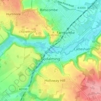
Название: Топографическая карта Godalming, высота, рельеф.
Местонахождение: Godalming, Waverley, Surrey, England, United Kingdom (51.16986 -0.64093 51.20806 -0.58489)
Средняя высота: 71 м
Минимальная высота: 31 м
Максимальная высота: 133 м
Сделать пожертвование