
Топографическая карта Kalpetta
Интерактивная карта
Нажмите на карту, чтобы отобразить высоту.
Kalpetta
Kalpetta is a major City, Town and municipality in the Wayanad district of the Indian state of Kerala. Kalpetta is the headquarters of Wayanad district, as well as the headquarters of Vythiri taluk. It is a bustling city, town surrounded by dense coffee and tea plantations and mountains. It lies on the Kozhikode-Mysore National Highway NH 766 (formerly NH 212) at an altitude of about 780 m above sea level. Kalpetta is 72 km from Kozhikode and 140 km from Mysore.
Об этой карте
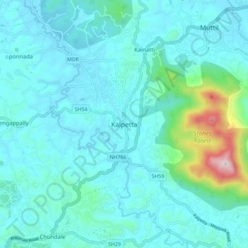
Название: Топографическая карта Kalpetta, высота, рельеф.
Местонахождение: Kalpetta, Vythiri, Wayanad, Kerala, 673121, India (11.57028 76.04281 11.65028 76.12281)
Средняя высота: 809 м
Минимальная высота: 722 м
Максимальная высота: 1 385 м