
Сделать пожертвование
Топографическая карта Fredericksburg
Нажмите на карту, чтобы отобразить высоту.
Сделать пожертвование
Fredericksburg
Enchanted Rock is a geographical landmark 27 km (17 mi) north of Fredericksburg in Llano County. The rock is a huge, pink granite exfoliation dome that rises 425 ft (130 m) above the surrounding land, has a summit elevation of 1,825 ft (556 m) above sea level, and covers 640 acres (260 ha). Enchanted Rock offers 8.4 miles of hiking trails, camping, picnicking, rock climbing, and other outdoor activities. It is one of the largest batholiths (underground rock formation uncovered by erosion) in the United States, and was declared a National Natural Landmark in 1970. In 1994, the State of Texas opened it as Enchanted Rock State Natural Area after adding facilities. The same year, Enchanted Rock was added to the National Register of Historic Places.
Сделать пожертвование
Об этой карте
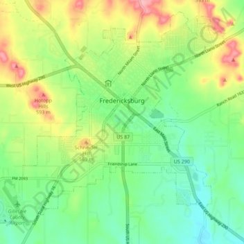
Название: Топографическая карта Fredericksburg, высота, рельеф.
Местонахождение: Fredericksburg, Gillespie County, Texas, United States (30.23534 -98.92082 30.30196 -98.83580)
Средняя высота: 526 м
Минимальная высота: 479 м
Максимальная высота: 605 м
Сделать пожертвование
Другие топографические карты
Нажмите на карту, чтобы просмотреть ее топографию, ее высоту и ее рельеф.
Fredericksburg
United States > Texas > Gillespie County
Enchanted Rock is a geographical landmark 27 km (17 mi) north of Fredericksburg in Llano County. The rock is a huge, pink granite exfoliation dome that rises 425 ft (130 m) above the surrounding land, has a summit elevation of 1,825 ft (556 m) above sea level, and covers 640 acres (260 ha). Enchanted Rock…
Средняя высота: 526 м
Сделать пожертвование
Fredericksburg
United States > Texas > Gillespie County
Enchanted Rock is a geographical landmark 27 km (17 mi) north of Fredericksburg in Llano County. The rock is a huge, pink granite exfoliation dome that rises 425 ft (130 m) above the surrounding land, has a summit elevation of 1,825 ft (556 m) above sea level, and covers 640 acres (260 ha). Enchanted Rock…
Средняя высота: 526 м
Сделать пожертвование