
Сделать пожертвование
Топографическая карта Forest Park
Нажмите на карту, чтобы отобразить высоту.
Сделать пожертвование
Об этой карте
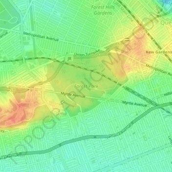
Название: Топографическая карта Forest Park, высота, рельеф.
Местонахождение: Forest Park, Queens, Queens County, New York, United States (40.69479 -73.87065 40.71173 -73.83447)
Средняя высота: 25 м
Минимальная высота: 4 м
Максимальная высота: 53 м
Сделать пожертвование
Другие топографические карты
Нажмите на карту, чтобы просмотреть ее топографию, ее высоту и ее рельеф.
Queens
United States > New York > Queens County > New York
Many of the village street grids of Queens had only worded names, some were numbered according to local numbering schemes, and some had a mix of words and numbers. In the early 1920s, a "Philadelphia Plan" was instituted to overlay one numbered system upon the whole borough. The Topographical Bureau, Borough…
Средняя высота: 11 м
Flushing Meadows-Corona Park
United States > New York > Queens County > New York
Around 1907, contractor Michael Degnon, whose firm constructed the Williamsburg Bridge, the Cape Cod Canal, and the Steinway subway tunnel (used by today's 7 and <7> trains), purchased large tracts of marsh near Flushing Creek. At the time, the land was considered "all but worthless". Degnon envisioned…
Средняя высота: 15 м
Сделать пожертвование
Queens
United States > New York > Queens County > New York
Many of the village street grids of Queens had only worded names, some were numbered according to local numbering schemes, and some had a mix of words and numbers. In the early 1920s, a "Philadelphia Plan" was instituted to overlay one numbered system upon the whole borough. The Topographical Bureau, Borough…
Средняя высота: 11 м