
Сделать пожертвование
Топографическая карта Braga
Нажмите на карту, чтобы отобразить высоту.
Сделать пожертвование
Braga
The topography in the municipality is characterized by irregular valleys, interspersed by mountainous spaces, fed by rivers running in parallel with the principal rivers. In the north it is limited by the Cávado River, in the south by terrain of the Serra dos Picos to a height of 566 metres (1,857 ft) and towards the east by the Serra dos Carvalhos to a height of 479 metres (1,572 ft), opening to the municipalities of Vila Nova de Famalicão and Barcelos. The territory extends from the northeast to southwest, accompanying the valleys of the two rivers, fed by many of its tributaries, forming small platforms between 20 metres (66 ft) and 570 metres (1,870 ft).
Сделать пожертвование
Об этой карте
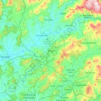
Название: Топографическая карта Braga, высота, рельеф.
Местонахождение: Braga, Maximinos, Sé e Cividade, Braga, 4700-435, Portugal (41.39106 -8.58800 41.71106 -8.26800)
Средняя высота: 204 м
Минимальная высота: 4 м
Максимальная высота: 908 м
Сделать пожертвование
Другие топографические карты
Нажмите на карту, чтобы просмотреть ее топографию, ее высоту и ее рельеф.