
Топографическая карта Gundagai
Интерактивная карта
Нажмите на карту, чтобы отобразить высоту.
Об этой карте
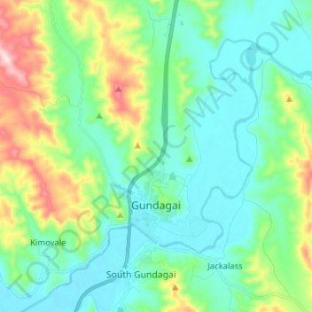
Название: Топографическая карта Gundagai, высота, рельеф.
Местонахождение: Gundagai, Cootamundra-Gundagai Regional Council, New South Wales, 2722, Australia (-35.09721 148.04383 -34.99232 148.14734)
Средняя высота: 309 м
Минимальная высота: 208 м
Максимальная высота: 622 м
Gundagai is an inland town with an elevation of 250 metres (820 ft). Almost all of the shire is located in the South West Slopes bio-region and is part of the Riverina agricultural region. The eastern part of the shire is considered part of the South Eastern Highlands bioregion.