
Сделать пожертвование
Топографическая карта Leesburg
Нажмите на карту, чтобы отобразить высоту.
Сделать пожертвование
Leesburg
Leesburg is located northeast of the center of Loudoun County at 39°7′N 77°33′W / 39.117°N 77.550°W / 39.117; -77.550 (39.109, −77.558), It is part of the northern Virginia Piedmont and sits at the base of the easternmost chain of the Blue Ridge Mountains, Catoctin Mountain. The town lies in the Culpeper Basin (an inland sea during the Jurassic period) and is adjacent to the valley of the Potomac River, so that the local relief is less pronounced than in other Virginia Piedmont towns. Elevation in town ranges from about 350 to 400 feet (110 to 120 m), with the ridge of Catoctin Mountain rising to 670 feet (200 m) just west of the town limits. The Town Branch of Tuscarora Creek passes through the center of town, flowing east to Goose Creek, a tributary of the Potomac.
Сделать пожертвование
Об этой карте
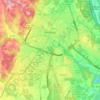
Название: Топографическая карта Leesburg, высота, рельеф.
Местонахождение: Leesburg, Loudoun County, Virginia, United States (39.06762 -77.60243 39.13853 -77.50793)
Средняя высота: 113 м
Минимальная высота: 32 м
Максимальная высота: 215 м
Сделать пожертвование
Другие топографические карты
Нажмите на карту, чтобы просмотреть ее топографию, ее высоту и ее рельеф.
Loudoun Valley Estates
United States > Virginia > Loudoun County
The land around Loudoun Valley Estates is gently rolling. The average elevation is 289 feet (88 m). The population density is about 500 people per square kilometer.
Средняя высота: 91 м
Сделать пожертвование
Сделать пожертвование
Сделать пожертвование