
Топографическая карта Amarnath Cave Temple
Интерактивная карта
Нажмите на карту, чтобы отобразить высоту.
Amarnath Cave Temple
The Shiva Lingam at the shrine is a Swayambhu lingam. The lingam is a natural stalagmite formation located at the Amarnath Mountain which has a peak of 5,186 metres (17,014 ft), and inside a 40 m (130 ft) high cave at an elevation of 3,888 m (12,756 ft). The stalagmite is formed due to the freezing of water drops that fall from the roof of the cave onto the floor resulting in an upward vertical growth of ice. There are different types of stalagmites. Here, the stalagmites considered as the lingam, a physical manifestation of Shiva, form a solid-dome-shape. Parvati and Ganesha are also present here as two smaller stalagmites.
Об этой карте
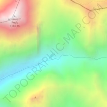
Название: Топографическая карта Amarnath Cave Temple, высота, рельеф.
Местонахождение: Amarnath Cave Temple, Amarnath, Pahalgam, Anantnag district, Jammu and Kashmir, India (34.20564 75.49383 34.22564 75.51383)
Средняя высота: 4 325 м
Минимальная высота: 3 719 м
Максимальная высота: 5 200 м
Другие топографические карты
Нажмите на карту, чтобы просмотреть ее топографию, ее высоту и ее рельеф.