
Сделать пожертвование
Топографическая карта Williams
Нажмите на карту, чтобы отобразить высоту.
Сделать пожертвование
Williams
Williams is located at 35°14′58″N 112°11′24″W / 35.24944°N 112.19000°W / 35.24944; -112.19000 (35.249369, −112.189872) at 6,800 feet (2,100 m) in elevation. Bill Williams Mountain rises to an elevation of 9,256 feet (2,821 m) just south of Williams. According to the United States Census Bureau, the city has a total area of 43.8 square miles (113 km2), of which 43.5 square miles (113 km2) is land and 0.3 square miles (0.78 km2), or 0.66%, is water.
Сделать пожертвование
Об этой карте
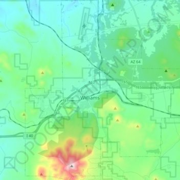
Название: Топографическая карта Williams, высота, рельеф.
Местонахождение: Williams, Coconino County, Arizona, 86046, United States (35.18978 -112.24731 35.32272 -112.10644)
Средняя высота: 2 131 м
Минимальная высота: 1 965 м
Максимальная высота: 2 811 м
Сделать пожертвование
Другие топографические карты
Нажмите на карту, чтобы просмотреть ее топографию, ее высоту и ее рельеф.
Grand Canyon Village
United States > Arizona > Coconino County
In 1910, while the Grand Canyon was still designated a national monument, Secretary of the Interior Richard A. Ballinger suggested that a plan be established before further development took place at the South Rim. Mark Daniels, the general superintendent of the parks from 1914, called for similar comprehensive…
Средняя высота: 1 999 м
Grand Canyon
United States > Arizona > Coconino County
Uplift associated with mountain formation later moved these sediments thousands of feet upward and created the Colorado Plateau. The higher elevation has also resulted in greater precipitation in the Colorado River drainage area, but not enough to change the Grand Canyon area from being semi-arid. The uplift…
Средняя высота: 1 023 м
Сделать пожертвование
Grand Canyon
United States > Arizona > Coconino County
Uplift associated with mountain formation later moved these sediments thousands of feet upward and created the Colorado Plateau. The higher elevation has also resulted in greater precipitation in the Colorado River drainage area, but not enough to change the Grand Canyon area from being semi-arid. The uplift…
Средняя высота: 1 023 м
Сделать пожертвование
Grand Canyon
United States > Arizona > Coconino County
Uplift associated with mountain formation later moved these sediments thousands of feet upward and created the Colorado Plateau. The higher elevation has also resulted in greater precipitation in the Colorado River drainage area, but not enough to change the Grand Canyon area from being semi-arid. The uplift…
Средняя высота: 1 023 м
Сделать пожертвование
Humphreys Peak
United States > Arizona > Coconino County
Humphreys Peak (Hopi: Aaloosaktukwi, Navajo: Dookʼoʼoosłííd "its summit never melts") is the highest mountain and the second most prominent peak after Mount Graham in the U.S. state of Arizona. With an elevation of 12,637 feet (3,852 m), it is located within the Kachina Peaks Wilderness in the Coconino…
Средняя высота: 3 412 м
Сделать пожертвование
Grand Canyon
United States > Arizona > Coconino County
Uplift associated with mountain formation later moved these sediments thousands of feet upward and created the Colorado Plateau. The higher elevation has also resulted in greater precipitation in the Colorado River drainage area, but not enough to change the Grand Canyon area from being semi-arid. The uplift…
Средняя высота: 1 023 м
Oak Creek Canyon
United States > Arizona > Coconino County
Oak Creek Canyon is about 12 miles (19 km) long, ranging in width from 0.8 to 2.5 miles (1.3 to 4.0 km). The depth of the canyon ranges from 800 to 2,000 feet (240 to 610 m). However, due to the faulting that played a major role in its formation, the west rim of the canyon is 700 feet (210 m) higher than the…
Средняя высота: 1 859 м
Сделать пожертвование
Oak Creek Canyon
United States > Arizona > Coconino County
Oak Creek Canyon is about 12 miles (19 km) long, ranging in width from 0.8 to 2.5 miles (1.3 to 4.0 km). The depth of the canyon ranges from 800 to 2,000 feet (240 to 610 m). However, due to the faulting that played a major role in its formation, the west rim of the canyon is 700 feet (210 m) higher than the…
Средняя высота: 1 859 м
Grand Canyon
United States > Arizona > Coconino County
Uplift associated with mountain formation later moved these sediments thousands of feet upward and created the Colorado Plateau. The higher elevation has also resulted in greater precipitation in the Colorado River drainage area, but not enough to change the Grand Canyon area from being semi-arid. The uplift…
Средняя высота: 1 023 м
Сделать пожертвование
Cow Springs
United States > Arizona > Coconino County
Cow Springs is a populated place situated in Coconino County, Arizona, United States. It has an estimated elevation of 5,863 feet (1,787 m) above sea level.
Средняя высота: 1 788 м
Сделать пожертвование
Flagstaff
United States > Arizona > Coconino County
Flagstaff, the county seat of Coconino County. According to the United States Census Bureau, the city has a total area of 63.9 square miles (165.5 km2), of which only 0.03 square miles (0.08 km2) (0.08%) is water. Flagstaff lies at approximately 7,000 feet (2,130 m) elevation, and is surrounded by the largest…
Средняя высота: 2 176 м
Сделать пожертвование
Сделать пожертвование
Bellemont
United States > Arizona > Coconino County
Bellemont is an unincorporated community in Coconino County, Arizona, United States, located along Interstate 40, about 11 miles (18 km) west-northwest of Flagstaff. At an elevation of 7,132 feet (2,174 m), it is claimed to be the highest settlement along historic Route 66. It was a known water stop due to its…
Средняя высота: 2 195 м
Сделать пожертвование
Сделать пожертвование
Сделать пожертвование
Сделать пожертвование
Bitter Springs
United States > Arizona > Coconino County
The mean elevation is 5,115 feet (1,559 m) above sea level. The US Postal Service ZIP code is 86040.
Средняя высота: 1 697 м
Flagstaff
United States > Arizona > Coconino County > Flagstaff
Flagstaff, the county seat of Coconino County. According to the United States Census Bureau, the city has a total area of 63.9 square miles (165.5 km2), of which only 0.03 square miles (0.08 km2) (0.08%) is water. Flagstaff lies at approximately 7,000 feet (2,130 m) elevation, and is surrounded by the largest…
Средняя высота: 2 230 м
Сделать пожертвование
Grand Canyon
United States > Arizona > Coconino County
Uplift associated with mountain formation later moved these sediments thousands of feet upward and created the Colorado Plateau. The higher elevation has also resulted in greater precipitation in the Colorado River drainage area, but not enough to change the Grand Canyon area from being semi-arid. The uplift…
Средняя высота: 1 023 м
Сделать пожертвование
Сделать пожертвование
Glen Canyon Dam
United States > Arizona > Coconino County
The Bureau of Reclamation favored the Echo Park site over Glen Canyon, because its narrow canyons and high elevation (more than 5,000 feet (1,500 m), as compared to 3,700 feet (1,100 m) at Glen Canyon) would lead to less evaporation. It said that building Echo Park Dam and a "low" Glen Canyon Dam would save…
Средняя высота: 1 171 м
Сделать пожертвование
Сделать пожертвование