
Топографическая карта Upper Arlington
Интерактивная карта
Нажмите на карту, чтобы отобразить высоту.
Upper Arlington
The city is around 800 ft elevation located between the Olentangy and Scioto rivers. Two ravines cut through the city. The Slate Run in the northwest corner flows into the Scioto River. However, the Turkey Run is longer. It originates in the north then runs southwards until it makes an eastward bend around Reed Rd. Then, it flows eastwards through the OSU Golf Course. The run is used as a storm drain at points, has been dammed in the Ohio State course and runs through concrete pipes at two points. The soil is glacial till and is suitable for agriculture, supporting a research farm operated by Ohio State University.
Об этой карте
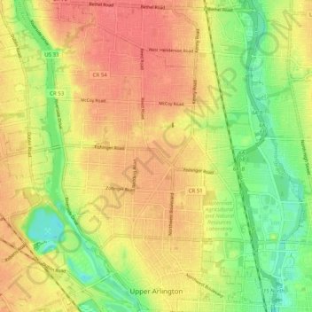
Название: Топографическая карта Upper Arlington, высота, рельеф.
Местонахождение: Upper Arlington, Franklin County, Ohio, United States (39.98929 -83.10452 40.06548 -83.04254)
Средняя высота: 249 м
Минимальная высота: 211 м
Максимальная высота: 279 м
Другие топографические карты
Нажмите на карту, чтобы просмотреть ее топографию, ее высоту и ее рельеф.
Columbus
United States > Ohio > Franklin County > Columbus
The confluence of the Scioto and Olentangy rivers is just north-west of Downtown Columbus. Several smaller tributaries course through the Columbus metropolitan area, including Alum Creek, Big Walnut Creek, and Darby Creek. Columbus is considered to have relatively flat topography thanks to a large glacier that…
Средняя высота: 255 м