
Сделать пожертвование
Топографическая карта Pindus
Нажмите на карту, чтобы отобразить высоту.
Сделать пожертвование
Pindus
The Pindus (also Pindos or Pindhos; Greek: Πίνδος, romanized: Píndos; Albanian: Pindet; Aromanian: Pindu) is a mountain range located in Northern Greece and Southern Albania. It is roughly 160 km (99 mi) long, with a maximum elevation of 2,637 metres (8,652 ft) (Mount Smolikas). Because it runs north to south along much of mainland Greece, the Pindus range is known colloquially as the spine of Greece. The mountain range stretches from near the Greek-Albanian border in southern Albania, entering the Epirus and Macedonia regions in northern Greece down to the north of the Peloponnese. Geologically, it is an extension of the Dinaric Alps, which dominate the western region of the Balkan Peninsula.
Сделать пожертвование
Об этой карте
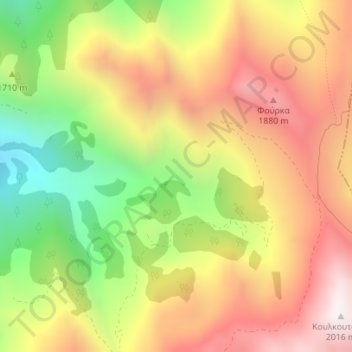
Название: Топографическая карта Pindus, высота, рельеф.
Местонахождение: Pindus, Argithea Municipality, Karditsa Regional Unit, Thessaly, Thessaly and Central Greece, Greece (39.33328 21.54995 39.33338 21.55005)
Средняя высота: 1 510 м
Минимальная высота: 942 м
Максимальная высота: 2 013 м
Сделать пожертвование
Другие топографические карты
Нажмите на карту, чтобы просмотреть ее топографию, ее высоту и ее рельеф.
Plastiras (Tavropos) Lake
Greece > Thessaly and Central Greece > Karditsa Regional Unit > Plastiras Municipal Unit
Today the lake holds up to 400 million cubic meters of fresh water. It is used for irrigation and as a power source of a hydroelectric plant, but also as the main water source to the city of Karditsa. Due to its altitude (one of the highest in Europe) the Tavropos Reservoir is a popular tourist resort in…
Средняя высота: 792 м
Municipal Unit of Tamasi
Greece > Thessaly and Central Greece > Karditsa Regional Unit
Средняя высота: 293 м