
Топографическая карта Cedar Hill
Интерактивная карта
Нажмите на карту, чтобы отобразить высоту.
Cedar Hill
It is sometimes referred to as the "hill country of Dallas" (in comparison to the "hill country" surrounding Austin and San Antonio). The city is full of native eastern red cedar evergreen trees and stands at an elevation of about 800 feet (240 m) above sea level—the highest point in a straight line from the Red River at the Texas-Oklahoma border to the Gulf Coast.
Об этой карте
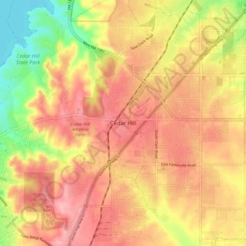
Название: Топографическая карта Cedar Hill, высота, рельеф.
Местонахождение: Cedar Hill, Dallas County, Texas, 75104-2135, United States (32.54881 -96.99537 32.62881 -96.91537)
Средняя высота: 225 м
Минимальная высота: 156 м
Максимальная высота: 268 м