
Сделать пожертвование
Топографическая карта Colombo
Нажмите на карту, чтобы отобразить высоту.
Сделать пожертвование
Colombo
It was founded on 5 February 1890. It is located at 25º17'30" S, 49º13'27" W, at an elevation of about 1000 metres above sea level, some 18 km from state capital Curitiba. The city is the largest Italian colony in the state.
Сделать пожертвование
Об этой карте
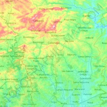
Название: Топографическая карта Colombo, высота, рельеф.
Средняя высота: 972 м
Минимальная высота: 866 м
Максимальная высота: 1 195 м
Сделать пожертвование
Другие топографические карты
Нажмите на карту, чтобы просмотреть ее топографию, ее высоту и ее рельеф.
Curitiba
Brazil > Paraná > Região Metropolitana de Curitiba
The city covers 432.17 km2 (166.86 sq mi) on the First Plateau of Paraná. Curitiba has a topography of smooth, rounded hills, giving it a relatively regular shape. The city has an average altitude of 934.6 m (3,066 ft) above sea level. The highest point is to the north at 1,021 m (3,350 ft), and with lower…
Средняя высота: 931 м
Сделать пожертвование
Curitiba
Brazil > Paraná > Região Metropolitana de Curitiba
The city covers 432.17 km2 (166.86 sq mi) on the First Plateau of Paraná. Curitiba has a topography of smooth, rounded hills, giving it a relatively regular shape. The city has an average altitude of 934.6 m (3,066 ft) above sea level. The highest point is to the north at 1,021 m (3,350 ft), and with lower…
Средняя высота: 931 м
Tijucas do Sul
Brazil > Paraná > Região Metropolitana de Curitiba > Tijucas do Sul > Tijucas do Sul
Средняя высота: 913 м