
Топографическая карта Montague Township
Интерактивная карта
Нажмите на карту, чтобы отобразить высоту.
Об этой карте
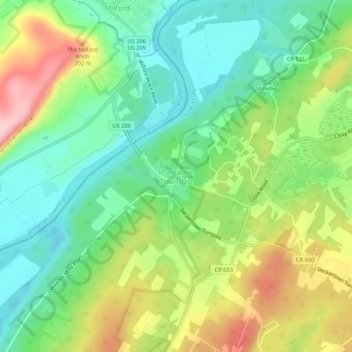
Название: Топографическая карта Montague Township, высота, рельеф.
Местонахождение: Montague Township, Sussex County, New Jersey, United States (41.28315 -74.81350 41.32315 -74.77350)
Средняя высота: 178 м
Минимальная высота: 104 м
Максимальная высота: 301 м
Montague Township is a township in Sussex County, in the U.S. state of New Jersey, in the New York City Metropolitan Area. As of the 2020 United States census, the township's population was 3,792, a decrease of 55 (−1.4%) from the 2010 census count of 3,847, which in turn reflected an increase of 435 (+12.7%) from the 3,412 counted in the 2000 census. High Point, within Montague Township, is the highest elevation within New Jersey at an altitude of 1,803 feet (550 m) above sea level. Montague is also the northernmost municipality in the state of New Jersey.
Другие топографические карты
Нажмите на карту, чтобы просмотреть ее топографию, ее высоту и ее рельеф.
High Point State Park
United States > New Jersey > Sussex County > Montague Township
High Point State Park, Montague Township, Sussex County, New Jersey, 07827, United States
Средняя высота: 255 м