
Сделать пожертвование
Топографическая карта Segovia
Нажмите на карту, чтобы отобразить высоту.
Сделать пожертвование
Segovia
Segovia has a hot-summer Mediterranean climate (Csa in the Köppen climate classification) bordering on a cold semi-arid climate (BSk), resulting from the high altitude and the distance from the coast. The average annual temperature is 12.42 °C (54.4 °F), with an average low in January of 0.3 °C (32.5 °F) and an average high in July of 29.7 °C (85.5 °F). The annual precipitation range from 400 to 500 mm per year in the lower plains, and can reach above 1000 mm in the nearby mountainous area of Sierra de Guadarrama, as rainfall and snowfall is more frequent up the mountains. Decent showers coming from summer thunderstorms help the mountainous area of the province to be rainier than average than most of the central Spanish plateau, which gives the area lush vegetation. All of this make the province a damp corner in the context of the region. The predominant forms of vegetation in the mountainous areas include pine, evergreen, oak, beech and juniper.
Сделать пожертвование
Об этой карте
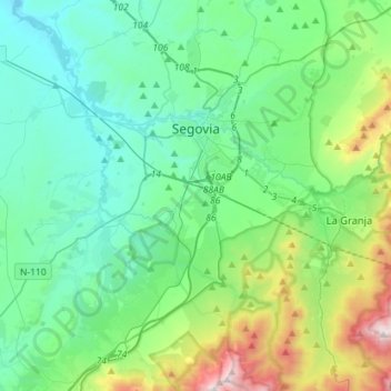
Название: Топографическая карта Segovia, высота, рельеф.
Местонахождение: Segovia, Castile and León, Spain (40.83472 -4.33675 40.98799 -4.05245)
Средняя высота: 1 143 м
Минимальная высота: 857 м
Максимальная высота: 2 193 м
Сделать пожертвование
Другие топографические карты
Нажмите на карту, чтобы просмотреть ее топографию, ее высоту и ее рельеф.
Сделать пожертвование
Сделать пожертвование
Сделать пожертвование
Сделать пожертвование
Сделать пожертвование
Сделать пожертвование
Yacimiento arqueológico La Edrada
Spain > Castile and León > El Bierzo > Cacabelos
Средняя высота: 493 м
Сделать пожертвование
Sierra de Guadarrama
The range runs southwest–northeast, extending from the province of Ávila in the southwest, through the Community of Madrid, to the province of Segovia in the northeast. The range measures approximately 80 kilometres (50 mi) in length. Its highest peak is Peñalara, 2,428 metres (7,966 ft) in elevation.
Средняя высота: 1 153 м
Сделать пожертвование
Сделать пожертвование
Сделать пожертвование
Сделать пожертвование
Сделать пожертвование
Сделать пожертвование
Сделать пожертвование
Сделать пожертвование
Сделать пожертвование
Сделать пожертвование
Сделать пожертвование
Сделать пожертвование
Сделать пожертвование
Сделать пожертвование
Poblado del Salto de Aldeadávila
Spain > Castile and León > Aldeadávila de la Ribera
Средняя высота: 535 м
Сделать пожертвование
Сделать пожертвование
Сделать пожертвование
Сделать пожертвование