
Сделать пожертвование
Топографическая карта Mount Olympus
Нажмите на карту, чтобы отобразить высоту.
Сделать пожертвование
Mount Olympus
With notable local relief, Mount Olympus ascends over 2,100 m (6,900 ft) from the 293 m (961 ft) elevation confluence of the Hoh River with Glacier Creek in only 8.8 km (5.5 mi). Mount Olympus has 2,386 m (7,828 ft) of prominence, ranking 5th in the state of Washington.
Сделать пожертвование
Об этой карте
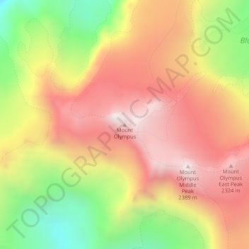
Название: Топографическая карта Mount Olympus, высота, рельеф.
Местонахождение: Mount Olympus, Jefferson County, Washington, United States (47.80117 -123.71096 47.80127 -123.71086)
Средняя высота: 1 934 м
Минимальная высота: 1 337 м
Максимальная высота: 2 396 м
Сделать пожертвование
Другие топографические карты
Нажмите на карту, чтобы просмотреть ее топографию, ее высоту и ее рельеф.
Сделать пожертвование
Hoh River
United States > Washington > Jefferson County
The Hoh River Trail, managed by the National Park Service, begins at the national park's Hoh Rain Forest Visitor Center at the end of the Upper Hoh Road. The trail follows the Hoh River east into the heart of the park. After 17.5 mi (28.2 km) it reaches Glacier Meadows near Mount Olympus's Blue Glacier. The…
Средняя высота: 534 м
Сделать пожертвование
Fort Townsend Historical State Park
United States > Washington > Jefferson County
Средняя высота: 57 м
Сделать пожертвование
Hoh River
United States > Washington > Jefferson County
The Hoh River Trail, managed by the National Park Service, begins at the national park's Hoh Rain Forest Visitor Center at the end of the Upper Hoh Road. The trail follows the Hoh River east into the heart of the park. After 17.5 mi (28.2 km) it reaches Glacier Meadows near Mount Olympus's Blue Glacier. The…
Средняя высота: 531 м
Сделать пожертвование