
Сделать пожертвование
Топографическая карта Outeiro de Rei
Нажмите на карту, чтобы отобразить высоту.
Сделать пожертвование
Outeiro de Rei
The town lies on a hill surrounded by the rivers Miño, Rato and Chanca. The difference in altitude between the city centre and the river banks is considerable: the former being at an altitude of 465 meters above sea level, whilst the Miño River Walk is at an altitude of only 364 metres (1,194 feet). The municipality of Lugo is the second largest in Galicia, with 329.78 square kilometres (127.33 sq mi) and 59 parishes. The outline of the city was declared a Biosphere Reserve by UNESCO on 7 November 2002, this being the most important recognition at international level regarding the conservation of landscapes and habitats of this Atlantic European region.
Сделать пожертвование
Об этой карте
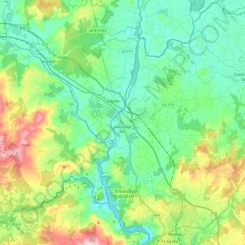
Название: Топографическая карта Outeiro de Rei, высота, рельеф.
Местонахождение: Outeiro de Rei, Lugo, Galicia, Spain (43.04711 -7.72654 43.16662 -7.49073)
Средняя высота: 443 м
Минимальная высота: 367 м
Максимальная высота: 634 м
Сделать пожертвование
Другие топографические карты
Нажмите на карту, чтобы просмотреть ее топографию, ее высоту и ее рельеф.