
Топографическая карта Aventura
Интерактивная карта
Нажмите на карту, чтобы отобразить высоту.
Об этой карте
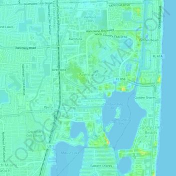
Название: Топографическая карта Aventura, высота, рельеф.
Местонахождение: Aventura, Miami-Dade County, Florida, United States (25.93109 -80.15032 25.97505 -80.12331)
Средняя высота: 7 м
Минимальная высота: -2 м
Максимальная высота: 36 м
In addition to its sea-level elevation, coastal location and position just north of the Tropic of Cancer, the area owes its warm, humid climate to the Gulf Stream, which moderates climate year-round. A typical summer day does not see temperatures below 75 °F (24 °C). Temperatures in the high 80s to low 90s (30–35 °C) accompanied by high humidity are often relieved by afternoon thunderstorms or a sea breeze that develops off the Atlantic Ocean, which then allow lower temperatures, although conditions still remain very muggy. During winter, humidity is significantly lower, allowing for cooler weather to develop. Average minimum temperatures during that time are around 59 °F (15 °C), rarely dipping below 40 °F (4 °C), and the equivalent maxima usually around 75 °F (24 °C).