Топографическая карта Saratoga Springs
Интерактивная карта
Нажмите на карту, чтобы отобразить высоту.
Об этой карте
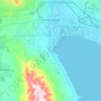
Название: Топографическая карта Saratoga Springs, высота, рельеф.
Местонахождение: Saratoga Springs, Utah County, Utah, 84045, United States (40.26063 -111.97839 40.41673 -111.85576)
Средняя высота: 1 500 м
Минимальная высота: 1 365 м
Максимальная высота: 2 339 м
Saratoga Springs is a city in Utah County, Utah, United States. The elevation is 4,505 feet. It is part of the Provo–Orem, Utah Metropolitan Statistical Area. The city is a relatively new development along the northwestern shores of Utah Lake. It was incorporated on December 31, 1997 and has been growing rapidly since then. The population was 37,696 at the 2020 Census. Saratoga Springs became a city in 2001.
Другие топографические карты
Нажмите на карту, чтобы просмотреть ее топографию, ее высоту и ее рельеф.
Provo
United States > Utah > Utah County
Provo, Utah County, Utah, United States
Средняя высота: 1 728 м
Woodland Hills
United States > Utah > Utah County
Woodland Hills, Utah County, Utah, United States
Средняя высота: 1 812 м
Mount Timpanogos
United States > Utah > Utah County
Mount Timpanogos, Utah County, Utah, 84602, United States
Средняя высота: 3 139 м
Elk Ridge
United States > Utah > Utah County
Elk Ridge, Utah County, Utah, United States
Средняя высота: 1 698 м
Townsend
United States > Utah > Utah County > Genola
Townsend, Genola, Utah County, Utah, 84655, United States
Средняя высота: 1 438 м
Pleasant View
United States > Utah > Utah County > Provo
Pleasant View, Provo, Utah County, Utah, 84604, United States
Средняя высота: 1 446 м
Salem
United States > Utah > Utah County
Salem, Utah County, Utah, 84653, United States
Средняя высота: 1 473 м
Lehi
United States > Utah > Utah County
Lehi, Utah County, Utah, 84043, United States
Средняя высота: 1 465 м
Lone Peak
United States > Utah > Utah County
Lone Peak, Utah County, Utah, 84092, United States
Средняя высота: 3 013 м
Springville
United States > Utah > Utah County
Springville, Utah County, Utah, 84663, United States
Средняя высота: 1 566 м
Pleasant Grove
United States > Utah > Utah County
Pleasant Grove, Utah County, Utah, 84062, United States
Средняя высота: 1 578 м
Eagle Mountain
United States > Utah > Utah County
Eagle Mountain, Utah County, Utah, 84005, United States
Средняя высота: 1 589 м
Vineyard
United States > Utah > Utah County
Vineyard, Utah County, Utah, 84059, United States
Средняя высота: 1 382 м
Santaquin
United States > Utah > Utah County > Santaquin
Santaquin, Utah County, Utah, 84655, United States
Средняя высота: 1 701 м
Lindon
United States > Utah > Utah County
Lindon, Utah County, Utah, 84042, United States
Средняя высота: 1 537 м
Payson
United States > Utah > Utah County > Payson
Payson, Utah County, Utah, 84651, United States
Средняя высота: 1 473 м