
Топографическая карта Bathwick Hill
Интерактивная карта
Нажмите на карту, чтобы отобразить высоту.
Об этой карте
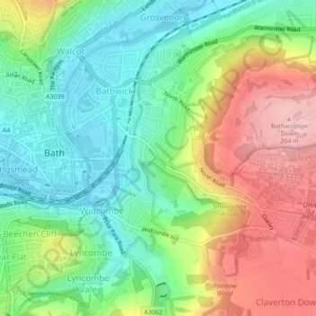
Название: Топографическая карта Bathwick Hill, высота, рельеф.
Местонахождение: Bathwick Hill, Bathwick, Bath, Bath and North East Somerset, West of England, England, BA2 6JY, United Kingdom (51.37092 -2.35549 51.39092 -2.33549)
Средняя высота: 93 м
Минимальная высота: 16 м
Максимальная высота: 208 м
Number 1 (Bathwick Lodge) is a 2-storey villa with a steep Mansard room, built in 1825, extended in 1840 and the late C19. Probably by John Pinch the Elder.[4] Number 2 is from the early 19th century and has shutters over the windows.[11] Number 3 includes a porch which is elaborately enriched with carving, Neo-Grecian gate posts and wrought iron gates.[12] Number 4 has a parapet which sweeps up to central balustrade with a rococo flourish,[13] as does number 5 which is also known as Cornwall Lodge.[14] Number 6, which is also known as Willow House, includes a wrought iron verandah on the 1st floor. Number 7 has a shallow hipped roof.[15] Number 8 has also been known as Upsala Villa[16] and later as Mendip Lodge.[17] The road elevation of number 9, built in 1820, extended in 1870, presents half an octagon in plan with overhanging eaves.[18]
Другие топографические карты
Нажмите на карту, чтобы просмотреть ее топографию, ее высоту и ее рельеф.
Sydney Gardens
United Kingdom > England > Bath and North East Somerset > Bath
Sydney Gardens, Bathwick, Bath, Bath and North East Somerset, West of England, England, United Kingdom
Средняя высота: 77 м