
Топографическая карта Longforgan
Интерактивная карта
Нажмите на карту, чтобы отобразить высоту.
Об этой карте
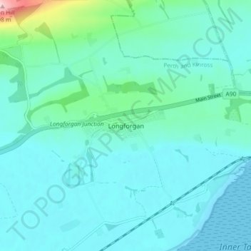
Название: Топографическая карта Longforgan, высота, рельеф.
Местонахождение: Longforgan, Perth and Kinross, Scotland, DD2 5EU, United Kingdom (56.43666 -3.13912 56.47666 -3.09912)
Средняя высота: 29 м
Минимальная высота: -1 м
Максимальная высота: 212 м
Другие топографические карты
Нажмите на карту, чтобы просмотреть ее топографию, ее высоту и ее рельеф.
The Birks of Aberfeldy
United Kingdom > Scotland > Perth and Kinross > Aberfeldy
Средняя высота: 222 м
Loch Tay
United Kingdom > Scotland > Perth and Kinross > Kenmore
In the Early Medieval period people began to cultivate the higher elevations of the hills around the loch. The Macnabs, the Menzies, the Drummonds, the Napiers, the Haldanes, the MacGregors and the Robertsons of Carwhin and Strowan all owned land around the loch but little remains of their possible…
Средняя высота: 460 м
Loch Leven National Nature Reserve
United Kingdom > Scotland > Perth and Kinross > Kinross
Средняя высота: 119 м
Glen Shee
United Kingdom > Scotland > Perth and Kinross > Spittal of Glenshee
The A93 road, part of General Wade's military road from Perth to Fort George, runs north through the glen and on into Glen Beag, where it crosses the Cairnwell Pass, which at an elevation of 2,200 feet (670 metres) is the highest public road in the UK. The road climbing to the summit is now wide and straight…
Средняя высота: 387 м
Loch Monzievaird
United Kingdom > Scotland > Perth and Kinross > Crieff > Monzievaird
Средняя высота: 121 м