
Сделать пожертвование
Топографическая карта College Park
Нажмите на карту, чтобы отобразить высоту.
Сделать пожертвование
College Park
The Lakeland neighborhood was developed beginning in 1890 around the Baltimore and Ohio Railroad, whose Branchville and Calvert Road depots were located approximately one mile to the north and south, respectively. Lakeland was created by Edwin Newman, who improved the original 238 acres (0.96 km2) located to the west of the railroad. He also built a number of the original homes, a small town hall, and a general store. The area was originally envisioned as a resort-type community. However, due to the flood-prone, low-lying topography, the neighborhood became an area of African-American settlement. Around 1900, the Baltimore Gold Fish Company built five artificial lakes in the area to spawn goldfish and rarer species of fish. By 1903 Lakeland was an established African-American community with a school and two churches. Lakeland was central in a group of African American communities located along Route One through Prince Georges County. Lakeland High School opened in 1928 with funding from the Rosenwald Fund, the African American community and the county. Lakeland High served all African American students in the northern half of the county until 1950 when it was converted to a facility for lower grades. The community's first Rosenwald school was a new elementary which opened in 1925.
Сделать пожертвование
Об этой карте
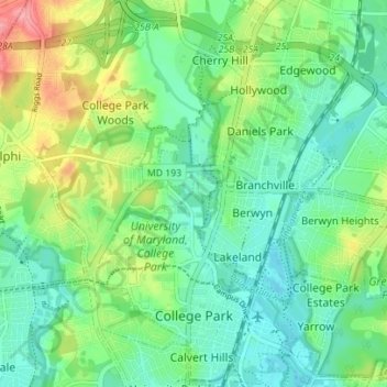
Название: Топографическая карта College Park, высота, рельеф.
Местонахождение: College Park, Prince George's County, Maryland, United States (38.97063 -76.96594 39.02487 -76.90893)
Средняя высота: 38 м
Минимальная высота: 10 м
Максимальная высота: 100 м
Сделать пожертвование
Другие топографические карты
Нажмите на карту, чтобы просмотреть ее топографию, ее высоту и ее рельеф.
Сделать пожертвование
Сделать пожертвование
Сделать пожертвование
Сделать пожертвование
Mount Rainier Neighborhood Park
United States > Maryland > Prince George's County > Mount Rainier
Средняя высота: 21 м
Farmington Road Estates
United States > Maryland > Prince George's County > Farmington Road Estates
Средняя высота: 47 м
Сделать пожертвование