
Сделать пожертвование
Топографическая карта Tlaxcala
Нажмите на карту, чтобы отобразить высоту.
Сделать пожертвование
Tlaxcala
Tlaxcala is a land-locked state situated on the Trans-Mexican Volcanic Belt. The average altitude for the state is 2,230 meters above sea level, making it a bit higher than the Valley of Mexico just to the southwest. The western part of the state lies on the central plateau of Mexico while the east is dominated by the Sierra Madre Oriental, home of the 4,461 meter La Malinche volcano. Most of the state is rugged terrain dominated by ridges and deep valleys, along with protruding igneous rock formations. This ruggedness, along with large-scale weather phenomena such as the Intertropical Convergence Zone, gives the state a complex climate. Overall rain patterns for the state are about 400 mm (16 in) in the summer rainy season and 30 mm (1.2 in) in the winter. Locally, however, this varies dramatically between the drier plateaus and valleys and the wetter mountains. Variations in altitude produce sub-climates between semi-tropical to temperate, with frosts likely in the higher elevations during the winter. Temperate forests of pine, fir (Abies religiosa), evergreen oak (Quercus ilex) and junipers (Juniperus communis) dominate the mountain highlands while the flatlands, with their drier climate, are characterized by agaves and prickly pear cactus (Opuntia).
Сделать пожертвование
Об этой карте
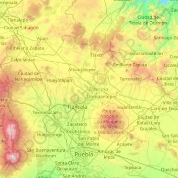
Название: Топографическая карта Tlaxcala, высота, рельеф.
Местонахождение: Tlaxcala, Mexico (19.10507 -98.70840 19.72892 -97.62544)
Средняя высота: 2 540 м
Минимальная высота: 1 279 м
Максимальная высота: 5 328 м
Сделать пожертвование
Другие топографические карты
Нажмите на карту, чтобы просмотреть ее топографию, ее высоту и ее рельеф.
Сделать пожертвование
Ciudad Juárez
Due to its location in the Chihuahuan Desert and high altitude, Ciudad Juárez has a cold desert climate (Köppen: BWk). Seasons are distinct, with hot summers, mild springs and autumns, and cold winters. Summer average high is 35 °C (95 °F) with lows of 21 °C (70 °F). Winter highs average 14 °C (57 °F)…
Средняя высота: 1 228 м
Сделать пожертвование
Сделать пожертвование
Acapulco
Mexico > Guerrero > Acapulco de Juárez
The city, located on the Pacific coast of Mexico in the state of Guerrero, is classified as one of the state's seven regions, dividing the rest of the Guerrero coast into the Costa Grande and the Costa Chica. Forty percent of the municipality is mountainous terrain; another forty percent is semi-flat; and the…
Средняя высота: 99 м
Сделать пожертвование
Villahermosa
Villahermosa is located in the southeast of Mexico between the rivers Grijalva and Carrizal. The average elevation of the city is 10 meters above sea level. The city also has several lagoons, the largest and most important of them being La Laguna de las Ilusiones (Illusions Lagoon).
Средняя высота: 9 м
Сделать пожертвование
Сделать пожертвование