

Сделать пожертвование
Топографическая карта Ore Mountains
Нажмите на карту, чтобы отобразить высоту.
Сделать пожертвование
Ore Mountains
The higher altitudes from around 500 m above sea level on the German side belong to the Ore Mountains/Vogtland Nature Park – the largest of its kind in Germany with a length of 120 km. The eastern Ore Mountains are protected landscape. Other smaller areas on the German and Czech sides are protected as nature reserves and natural monuments. On the ridges there are also several larger raised bogs that are only fed by rainwater. The mountains are popular for hiking and there are winter sports areas at higher elevations. In 2019, the region became a UNESCO World Heritage Site.
Сделать пожертвование
Об этой карте
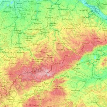
Название: Топографическая карта Ore Mountains, высота, рельеф.
Местонахождение: Ore Mountains, Saxony, Germany (50.19257 12.30729 51.02584 14.04725)
Средняя высота: 443 м
Минимальная высота: 89 м
Максимальная высота: 1 238 м
Сделать пожертвование
Другие топографические карты
Нажмите на карту, чтобы просмотреть ее топографию, ее высоту и ее рельеф.


Сделать пожертвование

Сделать пожертвование


Saxon Switzerland National Park
Germany > Saxony > Sächsische Schweiz-Osterzgebirge
Средняя высота: 356 м
Dresden
Dresden lies on both banks of the Elbe, mostly in the Dresden Basin, with the further reaches of the eastern Ore Mountains to the south, the steep slope of the Lusatian granitic crust to the north, and the Elbe Sandstone Mountains to the east at an altitude of about 113 metres (371 feet). Triebenberg is the…
Средняя высота: 204 м
Сделать пожертвование
Freiberg
Germany > Saxony > Mittelsachsen
The town lies on the northern declivity of the Ore Mountains, with the majority of the borough west of the Eastern or Freiberger Mulde river. Parts of the town are nestled in the valleys of Münzbach and Goldbach streams. Its centre has an altitude of about 412 m above sea level (NHN) (at the railway station).…
Средняя высота: 405 м

Сделать пожертвование
Сделать пожертвование
Sebnitz
Germany > Saxony > Sächsische Schweiz-Osterzgebirge
The town of Sebnitz lies in the valley of the river Sebnitz and its side valleys between 251 and 460 m above sea level between the mountains of Saxon Switzerland and the Lusatian Highlands. Topographically the town itself lies in the West Lusatian Upland, but lies right on the border with the Upper Lusatian…
Средняя высота: 342 м

Сделать пожертвование
Dresden
Dresden lies on both banks of the Elbe, mostly in the Dresden Basin, with the further reaches of the eastern Ore Mountains to the south, the steep slope of the Lusatian granitic crust to the north, and the Elbe Sandstone Mountains to the east at an altitude of about 113 metres (371 feet). Triebenberg is the…
Средняя высота: 204 м
Сделать пожертвование


Сделать пожертвование

Сделать пожертвование

Сделать пожертвование


Сделать пожертвование


Reinhardtsgrimma
Germany > Saxony > Sächsische Schweiz-Osterzgebirge > Glashütte
Средняя высота: 372 м
Сделать пожертвование
Сделать пожертвование

Сделать пожертвование


Сделать пожертвование


Сделать пожертвование


Deutschbaselitz - Němske Pazlicy
Germany > Saxony > Bautzen - Budyšin > Kamenz - Kamjenc
Средняя высота: 156 м
Сделать пожертвование


Сделать пожертвование


Сделать пожертвование

Marienberg
Germany > Saxony > Erzgebirgskreis
The town is situated on a plateau north of the Ore Mountains ridge, at an elevation between 460 and 891 metres above sea level. It is approximately 31 kilometres south of Chemnitz, to which it is connected via the Flöha Valley Railway.
Средняя высота: 657 м

Сделать пожертвование
Dresden
Dresden lies on both banks of the Elbe, mostly in the Dresden Basin, with the further reaches of the eastern Ore Mountains to the south, the steep slope of the Lusatian granitic crust to the north, and the Elbe Sandstone Mountains to the east at an altitude of about 113 metres (371 feet). Triebenberg is the…
Средняя высота: 204 м

02906
Germany > Saxony > Görlitz > Quitzdorf am See - Kwětanecy při jězoru > Sproitz > Hintersproitz
Средняя высота: 162 м
Сделать пожертвование


Innere Altstadt
Dresden lies on both banks of the Elbe, mostly in the Dresden Basin, with the further reaches of the eastern Ore Mountains to the south, the steep slope of the Lusatian granitic crust to the north, and the Elbe Sandstone Mountains to the east at an altitude of about 113 metres (371 feet). Triebenberg is the…
Средняя высота: 117 м

Сделать пожертвование


Markersbach
Germany > Saxony > Erzgebirgskreis
In 1889, Markersbach was connected to the railway line from Schwarzenberg to Annaberg, which was closed to passenger transport on 27 September 1997. The station lay in Mittweida’s municipal area and the platform signs read Mittweida-Markersbach. To overcome the great elevation differential, the railway's…
Средняя высота: 600 м

Сделать пожертвование


Сделать пожертвование


Сделать пожертвование