
Сделать пожертвование
Топографическая карта Petrolina
Нажмите на карту, чтобы отобразить высоту.
Сделать пожертвование
Petrolina
Petrolina is situated on the left (northern) bank of the São Francisco River, in the interior semi-arid Sertão subregion, at an elevation of 376 m. On the other side of the river sits Juazeiro, in state of Bahia, and together the cities form an integrated metropolitan area. The two cities, making up an urban area of almost 700,000 people, are connected by the President Dutra Bridge. The Sobradinho Dam is located 26 km up river, and creates the Sobradinho Reservoir, the 34th largest reservoir by volume in the world.
Сделать пожертвование
Об этой карте
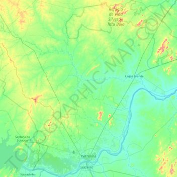
Название: Топографическая карта Petrolina, высота, рельеф.
Средняя высота: 420 м
Минимальная высота: 349 м
Максимальная высота: 740 м
Сделать пожертвование
Другие топографические карты
Нажмите на карту, чтобы просмотреть ее топографию, ее высоту и ее рельеф.
Boa Paz
Brazil > Pernambuco > Região Administrativa Integrada de Desenvolvimento do Polo Petrolina e Juazeiro > Petrolina
Средняя высота: 379 м