
Сделать пожертвование
Топографическая карта Uttarakhand
Нажмите на карту, чтобы отобразить высоту.
Сделать пожертвование
Uttarakhand
Uttarakhand lies on the southern slope of the Himalaya range, and the climate and vegetation vary greatly with elevation, from glaciers at the highest elevations to subtropical forests at the lower elevations. The highest elevations are covered by ice and bare rock. Below them, between 3,000 and 5,000 metres (9,800 and 16,400 ft) are the western Himalayan alpine shrub and meadows. The temperate western Himalayan subalpine conifer forests grow just below the tree line. At 3,000 to 2,600 metres (9,800 to 8,500 ft) elevation they transition to the temperate western Himalayan broadleaf forests, which lie in a belt from 2,600 to 1,500 metres (8,500 to 4,900 ft) elevation. Below 1,500 metres (4,900 ft) elevation lie the Himalayan subtropical pine forests. The Upper Gangetic Plains moist deciduous forests and the drier Terai-Duar savanna and grasslands cover the lowlands along the Uttar Pradesh border in a belt locally known as Bhabar. These lowland forests have mostly been cleared for agriculture, but a few pockets remain.
Сделать пожертвование
Об этой карте
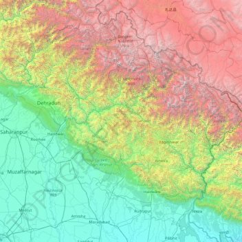
Название: Топографическая карта Uttarakhand, высота, рельеф.
Местонахождение: Uttarakhand, India (28.71579 77.57133 31.45902 81.04479)
Средняя высота: 2 102 м
Минимальная высота: 160 м
Максимальная высота: 7 442 м
Сделать пожертвование
Другие топографические карты
Нажмите на карту, чтобы просмотреть ее топографию, ее высоту и ее рельеф.
Dehradun
India > Uttarakhand > Dehradun
The city of Dehradun mainly lies in Doon Valley and is at a varying height from 410 m (1,350 ft) in Clement Town to above 700 m (2,300 ft) at Malsi which is 15 km (9.3 mi) from the city. However, the average elevation is 450 m (1,480 ft) above sea level. Malsi is the starting point of Lesser Himalayan Range…
Средняя высота: 904 м
Mussoorie
India > Uttarakhand > Dehradun
Mussoorie is at an average altitude of 2,005 metres (6,578 ft). To the northeast are the Himalayan snow ranges, and to the south, the Doon Valley and Shiwalik ranges. The second highest point is the original Lal Tibba in Landour, with a height of over 2,275 m (7,464 ft). Mussoorie is popularly known as The…
Средняя высота: 1 594 м
Rishikesh
India > Uttarakhand > Rishikesh
Rishikesh is at 30°06′12″N 78°17′41″E / 30.103368°N 78.294754°E / 30.103368; 78.294754. It has an average elevation of 372 metres (1,220 ft). The town is located in the Tehri Garhwal region of the northern Indian state of Uttarakhand.
Средняя высота: 497 м
Сделать пожертвование
Сделать пожертвование
Сделать пожертвование
Сделать пожертвование
Nainital
India > Uttarakhand > Nainital
The city of Nainital covers a total area of 11.73 km2 (4.53 sq mi), and is located at 29°23′N 79°27′E / 29.38°N 79.45°E / 29.38; 79.45, at an average elevation of 2,084 metres (6,837 ft) above sea level. The slopes of the nearby mountains are most populated, with an elevation ranging from…
Средняя высота: 1 813 м
Roorkee
India > Uttarakhand > Roorkee
Roorkee is located at 29°52′N 77°53′E / 29.87°N 77.88°E / 29.87; 77.88. It has an average elevation of 268 metres (879 ft).
Средняя высота: 270 м
Сделать пожертвование
Сделать пожертвование
Almora
India > Uttarakhand > Almora
Almora is located at 29°35′50″N 79°39′33″E / 29.5971°N 79.6591°E / 29.5971; 79.6591 in Almora district in Uttarakhand. Almora is situated 365 km north-east the national capital New Delhi and 415 km south-east the state capital Dehradun. It lies in the revenue Division Kumaon and is located…
Средняя высота: 1 557 м
Сделать пожертвование
Roopkund Lake
India > Uttarakhand > Chamoli Tehsil
Roopkund (locally known as Mystery Lake or Skeleton Lake) is a high altitude glacial lake in the Uttarakhand state of India. It lies in the lap of Trishul massif. Located in the Himalayas, the area around the lake is uninhabited and is roughly at an altitude of 5,020 metres (16,470 ft), surrounded by…
Средняя высота: 4 631 м
Сделать пожертвование
Сделать пожертвование
Сделать пожертвование
Сделать пожертвование
Сделать пожертвование
Gauchar
India > Uttarakhand > Karnaprayag
Gauchar (Garhwali: Gòchàr ) is a Hill Town sort of a valley town located in Karnaprayag tehsil within Chamoli district of Uttarakhand state in India. Gauchar is situated on the left bank of river Alaknanda and is en route to the celebrated holy destination of Badrinath. It is well known for being one of the…
Средняя высота: 1 196 м
Сделать пожертвование
Сделать пожертвование
Gopeshwar
India > Uttarakhand > Chamoli Tehsil
Gopeshwar is located at 30°25′N 79°20′E / 30.42°N 79.33°E / 30.42; 79.33. It has an average elevation of 1,450 m (4,760 ft). Gopeshwar is 8.4 km (5.2 mi) away from Chamoli which is located on the banks of Alaknanda river and along NH 58. Gopeshwar is able to captivate any visitor with its…
Средняя высота: 1 566 м
Сделать пожертвование
Сделать пожертвование
Сделать пожертвование
Сделать пожертвование
Сделать пожертвование
Сделать пожертвование
Kotdwar
India > Uttarakhand > Kotdwara
Kotdwar lies on the western margin of the Himalayas, at an altitude of 454 m (1,490 ft) above sea level.
Средняя высота: 471 м
Сделать пожертвование
Uttarkashi
India > Uttarakhand > Bhatwari
It is the district headquarters of Uttarkashi district. Uttarkashi is situated on the banks of river Bhagirathi at an altitude of 1158 m above sea level. Uttarkashi is generally known as a holy town close to Rishikesh. It is located in the state of Uttarakhand in India. Uttarkashi is home to a number of…
Средняя высота: 1 619 м
Сделать пожертвование
Сделать пожертвование
Сделать пожертвование
Ramganga Dam
India > Uttarakhand > Kotdwara
The dam is a 128 m (420 ft) tall and 630 m (2,067 ft) long earth and rock-fill embankment dam with 10,000,000 m3 (13,079,506 cu yd) of fill. The dam's spillway is controlled by five gates and has a maximum discharge of 8,467 m3/s (299,009 cu ft/s). To support the reservoir's elevation, there is a 72 m (236 ft)…
Средняя высота: 389 м
Сделать пожертвование