
Сделать пожертвование
Топографическая карта Rajasthan
Нажмите на карту, чтобы отобразить высоту.
Сделать пожертвование
Rajasthan
The Aravalli Range runs across the state from the southwest peak Guru Shikhar (Mount Abu), which is 1,722 metres (5,650 ft) in height, to Khetri in the northeast. This range divides the state into 60% in the northwest of the range and 40% in the southeast. The northwest tract is sandy and unproductive with little water but improves gradually from desert land in the far west and northwest to comparatively fertile and habitable land towards the east. The area includes the Thar Desert. The south-eastern area, higher in elevation (100 to 350 m above sea level) and more fertile, has a very diversified topography. In the south lies the hilly tract of Mewar. In the southeast, a large area within the districts of Kota and Bundi forms a tableland. To the northeast of these districts is a rugged region (badlands) following the line of the Chambal River. Farther north the country levels out; the flat plains of the northeastern Bharatpur district are part of an alluvial basin. Merta City lies in the geographical center of Rajasthan.
Сделать пожертвование
Об этой карте
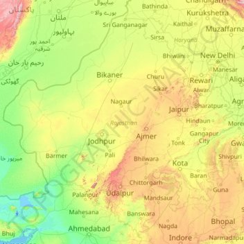
Название: Топографическая карта Rajasthan, высота, рельеф.
Местонахождение: Rajasthan, India (23.05866 69.48444 30.19825 78.27201)
Средняя высота: 254 м
Минимальная высота: -5 м
Максимальная высота: 2 299 м
Сделать пожертвование
Другие топографические карты
Нажмите на карту, чтобы просмотреть ее топографию, ее высоту и ее рельеф.
Western Ghats
The range starts near south of the Tapti river and runs approximately 1,600 km (990 mi) through the states of Gujarat, Maharashtra, Karnataka, Goa, Kerala and Tamil Nadu ending at Marunthuvazh Malai, Swamithope near the southern tip of India. These hills cover 160,000 km2 (62,000 sq mi) and form the catchment…
Средняя высота: 2 225 м
Сделать пожертвование
Mumbai
Mumbai lies at the mouth of the Ulhas River on the western coast of India, in the coastal region known as the Konkan. It sits on Salsette Island (Sashti Island), which it partially shares with the Thane district. Mumbai is bounded by the Arabian Sea to the west. Many parts of the city lie just above sea level,…
Средняя высота: 13 м
Maharashtra
Maharashtra is the third largest state by area in India. The Western Ghats better known as Sahyadri, are a hilly range running parallel to the coast, at an average elevation of 1,200 metres (4,000 ft). Kalsubai, a peak in the Sahyadris, near Nashik city is the highest elevated point in Maharashtra. To the west…
Средняя высота: 478 м
Deeg
India > Rajasthan > Deeg Tehsil
Deeg is located at 27°28′N 77°20′E / 27.47°N 77.33°E / 27.47; 77.33. It has an average elevation of 174 m (571 ft).
Средняя высота: 183 м
Сделать пожертвование
Idamalayar Dam
The Idamalayar Dam is located on the Idamalayar River, a tributary of the Periyar River in Kerala. Edamalayar originates in the Anamala Hills at elevation of 2,520 metres (8,270 ft). The river is a perennial source draining a catchment area of 381 km2 (147 sq mi) with a topography of high relief. The catchment…
Средняя высота: 257 м
Thiruvananthapuram
India > Kerala > Thiruvananthapuram
Thiruvananthapuram is built on seven hills by the seashore and is at 8°30′N 76°54′E / 8.5°N 76.9°E / 8.5; 76.9 on the west coast, near the southern tip of mainland India. The city is on the west coast of India and is bounded by the Laccadive Sea to its west and the Western Ghats to its east.…
Средняя высота: 33 м
Сделать пожертвование
Dharamshala
India > Himachal Pradesh > Dharamshala
The town is located in the Kangra Valley, in the shadow of the Dhauladhar range of the Himalayas at an altitude of 1,457 metres (4,780 ft). References to Dharamshala and its surrounding areas are found in ancient Hindu scriptures such as Rig Veda and Mahabharata. The region was under Mughal influence before it…
Средняя высота: 1 781 м
Сделать пожертвование
Сделать пожертвование
Lucknow
India > Uttar Pradesh > Lucknow
The city stands at an elevation of approximately 123 metres (404 ft) above sea level. Lucknow city had an area of 402 km2 (155 square miles) till December 2019, when 88 villages were added to the municipal limits and the area increased to 631 km2 (244 square miles). Bounded on the east by Barabanki, on the…
Средняя высота: 120 м
Madurai
India > Tamil Nadu > Madurai
Madurai is located at 9°56′N 78°07′E / 9.93°N 78.12°E / 9.93; 78.12. It has an average elevation of 101 metres. The city of Madurai lies on the flat and fertile plain of the river Vaigai, which runs in the northwest-southeast direction through the city, dividing it into two almost equal…
Средняя высота: 138 м
Сделать пожертвование
Сделать пожертвование
Anupgarh
India > Rajasthan > Anupgarh Tehsil
Anupgarh has an average elevation of 155 metres (508 feet), and is very close to the border with Pakistan. The fort at Anupgarh was built about 1689 by the Mughal governor to help suppress the local Bhati Rajputs who were rebelling.
Средняя высота: 155 м
Jhalawar
India > Rajasthan > Jhalrapatan Tehsil
Jhalawar is located at 24°36′N 76°09′E / 24.6°N 76.15°E / 24.6; 76.15. It has an average elevation of 312 metres (1023 feet).
Средняя высота: 319 м
Сделать пожертвование
Dhari
India > Gujarat > Dhari Taluka
Dhari is located at 21°19′36″N 71°01′31″E / 21.3266°N 71.0253°E / 21.3266; 71.0253. It has an average elevation of 216m (708') above sea level. The city is located in Saurashtra region of Gujarat and is situated near the Shetrunji River, which is passes north of Palitana's hills,…
Средняя высота: 221 м
Rishikesh
India > Uttarakhand > Rishikesh
Rishikesh is at 30°06′12″N 78°17′41″E / 30.103368°N 78.294754°E / 30.103368; 78.294754. It has an average elevation of 372 metres (1,220 ft). The town is located in the Tehri Garhwal region of the northern Indian state of Uttarakhand.
Средняя высота: 497 м
Сделать пожертвование
Сделать пожертвование
Сделать пожертвование
Сделать пожертвование
Kakinada
India > Andhra Pradesh > Kakinada (Urban)
Kakinada is located at 16°56′N 82°13′E / 16.93°N 82.22°E / 16.93; 82.22. The 82-degrees east longitude passes through the city. It has an average elevation of 2 metres (6 ft), and many areas of the city are below sea level.
Средняя высота: 7 м
Srinagar
India > Jammu and Kashmir > Srinagar (South)
Under the Köppen climate classification, Srinagar has a four-season humid subtropical climate (Cfa) with hot summers and cool winters. The valley is surrounded by the Himalayas on all sides. Due to influence from Himalayan rain shadow and western disturbances, Srinagar has year-round precipitation; the spring…
Средняя высота: 1 805 м
Vadodara
India > Gujarat > Vadodara Rural Taluka
Vadodara is located at 22°18′N 73°11′E / 22.30°N 73.19°E / 22.30; 73.19 in western India at an elevation of 39 metres (128 ft). It is the tenth-largest city in India with an area of 400 square kilometres (150 sq mi) and a population of 3.5 million, according to the 2010–11 census. The city…
Средняя высота: 36 м
Сделать пожертвование
Guwahati
Professor Abani Kumar Bhagawati of Gauhati University stated that since before there were sufficient wetlands to absorb rainwater and channels to carry excess water to the Brahmaputra, the city did not experience floods. However, human interference has disrupted the natural topography, leading to the current…
Средняя высота: 113 м
Dehradun
India > Uttarakhand > Dehradun
The city of Dehradun mainly lies in Doon Valley and is at a varying height from 410 m (1,350 ft) in Clement Town to above 700 m (2,300 ft) at Malsi which is 15 km (9.3 mi) from the city. However, the average elevation is 450 m (1,480 ft) above sea level. Malsi is the starting point of Lesser Himalayan Range…
Средняя высота: 904 м
Сделать пожертвование
Сделать пожертвование
Сделать пожертвование
Kargil
India > Ladakh > Kargil tehsil
Kargil has an average elevation of 2,676 metres (8,780 feet), and is situated along the banks of the Suru River (Indus). The town of Kargil is located 205 km (127 mi) from Srinagar, facing the Northern Areas across the LOC. Like other areas in the Himalayas, Kargil has a temperate climate. Summers are hot with…
Средняя высота: 3 262 м
Mangaluru
India > Karnataka > Mangaluru taluk
Mangalore is also the administrative headquarters of the Dakshina Kannada district; it is a commercial, industrial, educational, healthcare, and startup hub. The city's international airport is the second-largest and second-busiest airport in Karnataka. Mangalore City Corporation is responsible for the civic…
Средняя высота: 25 м
Сделать пожертвование
Indore
India > Madhya Pradesh > Juni Indore Tahsil
Indore /ɪnˈdɔːr/ (listen) is the most populous and the largest city in the Indian state of Madhya Pradesh. It serves as the headquarters of both Indore District and Indore Division. It is also considered as an education hub of the state and has campuses of both the Indian Institute of Technology and the…
Средняя высота: 555 м
Lucknow
India > Uttar Pradesh > Lucknow
Lucknow stands at an elevation of approximately 123 metres (404 ft) above sea level. The city had an area of 402 km2 (155 square miles) until December 2019, when 88 villages were added to the municipal limits and the area increased to 631 km2 (244 square miles). Bounded on the east by Barabanki, on the west by…
Средняя высота: 120 м
Navi Mumbai
India > Maharashtra > Thane > Navi Mumbai
Navi Mumbai (Marathi pronunciation: , also known by its former name New Bombay), is a planned city off the west coast of the Indian state of Maharashtra in Konkan division. The city is divided into two parts, North Navi Mumbai and South Navi Mumbai, for the individual development of Panvel Mega City, which…
Средняя высота: 30 м
Сделать пожертвование
Vellore
India > Tamil Nadu > Vellore
Vellore is at 12°55′N 79°08′E / 12.92°N 79.13°E / 12.92; 79.13, 220m above sea level. The city has a tropical savanna climate. It is in the Vellore district of the South Indian state, Tamil Nadu, 135 km (84 mi) west of the state capital Chennai and 30 km (19 mi) kms South of its twin city…
Средняя высота: 283 м
Surat
India > Gujarat > Katargam Taluka > Surat
Surat is a port city situated on the banks of the Tapi river. Damming of the Tapi caused the original port facilities to close; the nearest port is now in the Magadalla and Hazira area of Surat Metropolitan Region.It has famous beach called 'Dumas Beach' located in Hazira. The city is located at 21°10′N…
Средняя высота: 11 м
Сделать пожертвование
Сделать пожертвование
Сделать пожертвование
Сделать пожертвование
Сделать пожертвование
Сделать пожертвование
Сделать пожертвование