
Сделать пожертвование
Топографическая карта Triunfo
Нажмите на карту, чтобы отобразить высоту.
Сделать пожертвование
Triunfo
Triunfo is a municipality in the Northeastern Brazilian state of Pernambuco. The estimated population in 2020, according to the Brazilian Institute of Geography and Statistics (IBGE) was 15,243. The area of the municipality is 191.52 km2, and in 2010 the population density was 78 inhabitants/km2. Triunfo sits at an elevation of 1,004 metres (3,294 ft) in a forested part of the Sertão, and is the highest municipality in Pernambuco.
Сделать пожертвование
Об этой карте
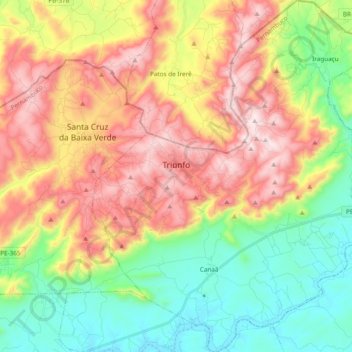
Название: Топографическая карта Triunfo, высота, рельеф.
Средняя высота: 759 м
Минимальная высота: 435 м
Максимальная высота: 1 175 м
Сделать пожертвование
Другие топографические карты
Нажмите на карту, чтобы просмотреть ее топографию, ее высоту и ее рельеф.
Ana de Alburquerque
Brazil > Pernambuco > Região Metropolitana do Recife > Igarassu
Средняя высота: 17 м
Сделать пожертвование
Boa Paz
Brazil > Pernambuco > Região Administrativa Integrada de Desenvolvimento do Polo Petrolina e Juazeiro > Petrolina
Средняя высота: 379 м
Fernando de Noronha
Fernando de Noronha (Portuguese pronunciation: [feʁˈnɐ̃du dʒi noˈɾoɲɐ]) is an archipelago in the Atlantic Ocean, part of the State of Pernambuco, Brazil, and located 354 km (191 nmi; 220 mi) off the Brazilian coast. It consists of 21 islands and islets, extending over an area of 26 km2 (10 sq mi).…
Средняя высота: 4 м
Сделать пожертвование
Saint Peter and Saint Paul Archipelago
The Saint Peter and Saint Paul Rocks are situated in the Atlantic Ocean, 100 km (62 mi) north of the Equator, and are the only group of Brazilian oceanic islets in the Northern Hemisphere. The nearest point in the Brazilian coast, is Cabo do Calcanhar, Rio Grande do Norte, approximately 1,010 kilometres (630…
Средняя высота: 0 м