
Топографическая карта Calverstown
Интерактивная карта
Нажмите на карту, чтобы отобразить высоту.
Об этой карте
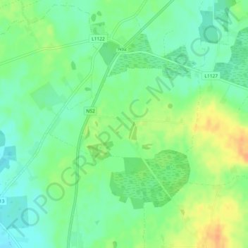
Название: Топографическая карта Calverstown, высота, рельеф.
Местонахождение: Calverstown, Clonfad ED, The Municipal District of Athlone — Moate, County Westmeath, Leinster, Ireland (53.42126 -7.39411 53.43370 -7.36591)
Средняя высота: 97 м
Минимальная высота: 83 м
Максимальная высота: 117 м
Другие топографические карты
Нажмите на карту, чтобы просмотреть ее топографию, ее высоту и ее рельеф.
Aghafin
Aghafin, Noughaval ED, The Municipal District of Athlone — Moate, County Westmeath, Leinster, Ireland
Средняя высота: 61 м
Castlelost
Castlelost, Castlelost ED, The Municipal District of Mullingar — Kinnegad, County Westmeath, Leinster, Ireland
Средняя высота: 93 м
Ballygarvey
Ballygarvey, Glenlough ED, The Municipal District of Athlone — Moate, County Westmeath, Leinster, Ireland
Средняя высота: 66 м
Rathnew
Rathnew, Ballymorin ED, The Municipal District of Athlone — Moate, County Westmeath, Leinster, Ireland
Средняя высота: 134 м
The Municipal District of Athlone — Moate
The Municipal District of Athlone — Moate, County Westmeath, Leinster, Ireland
Средняя высота: 69 м
Mullingar
Mullingar, The Municipal District of Mullingar — Kinnegad, County Westmeath, Leinster, Ireland
Средняя высота: 99 м
Garrycastle
Ireland > County Westmeath > Garrycastle
Garrycastle, Athlone East Rural ED, The Municipal District of Athlone — Moate, County Westmeath, Leinster, Ireland
Средняя высота: 49 м
Athlone
Ireland > County Westmeath > Athlone
Athlone, The Municipal District of Athlone — Moate, County Westmeath, Leinster, N37 N1F2, Ireland
Средняя высота: 44 м
Mullingar
Ireland > County Westmeath > Mullingar
Mullingar, The Municipal District of Mullingar — Kinnegad, County Westmeath, Leinster, N91 FY58, Ireland
Средняя высота: 101 м