
Сделать пожертвование
Топографическая карта Carson City
Нажмите на карту, чтобы отобразить высоту.
Сделать пожертвование
Carson City
Most of the city proper resides in the Eagle Valley. The Carson River flows from Douglas County through the southwestern edge of both the valley and Carson City. Since the consolidation, the city limits today include several small populated areas outside of this valley. Today the city limits include several peaks in the Sierra Nevada, small portions of both the Virginia Range and the Pine Nut Mountains and portions of Marlette Lake and Lake Tahoe. The highest elevation in city limits is Snow Valley Peak at an elevation of 9,214 feet (2,808 m). Carson City is one of two state capitals that border another state, the other being Trenton, New Jersey.
Сделать пожертвование
Об этой карте
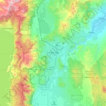
Название: Топографическая карта Carson City, высота, рельеф.
Местонахождение: Carson City, Nevada, United States (39.08480 -120.00608 39.25093 -119.54831)
Средняя высота: 1 832 м
Минимальная высота: 1 311 м
Максимальная высота: 3 266 м
Сделать пожертвование
Другие топографические карты
Нажмите на карту, чтобы просмотреть ее топографию, ее высоту и ее рельеф.
Сделать пожертвование
Сделать пожертвование
Blue Diamond
United States > Nevada > Clark County
Blue Diamond is the site of Cottonwood Spring (formerly known as Ojo de Cayetana, or Pearl Spring), a watering place and campsite on the Old Spanish Trail and the later Mormon Road between Mountain Springs and Las Vegas Springs. The springs are located on a mountainside south of the town at 36°02′44″N…
Средняя высота: 1 106 м
Сделать пожертвование
Highland Range Crucial Bighorn Habitat Area
United States > Nevada > Clark County
Средняя высота: 917 м
Сделать пожертвование
Devils Hole
United States > Nevada > Nye County
Devils Hole is a geothermal pool within a limestone cavern in the Amargosa Desert in the Amargosa Valley of Nevada, east over the Amargosa Range and Funeral Mountains from Death Valley. It is at an elevation of 730 m (2,400 ft) above sea level and the water is a constant temperature of 33 °C (91 °F). The…
Средняя высота: 756 м
Сделать пожертвование
Boundary Peak
United States > Nevada > Esmeralda County
Boundary Peak is a mountain in Esmeralda County, Nevada, United States. With a peak elevation of 13,147 feet (4,007 m), it is the highest natural point in the state of Nevada.
Средняя высота: 3 515 м
Mason Valley Swimming Pool Park
United States > Nevada > Lyon County > Yerington
Средняя высота: 1 336 м
Сделать пожертвование
Amargosa Valley
United States > Nevada > Nye County
Amargosa Valley is located at 36.58001 North, 116.44487 West at an elevation of 2,640 feet (805 m) above sea level. The landscape is typical of lower to moderate elevations in the Mojave Desert, with flat expanses of sandy soil punctuated by rocky mounds and hills. Predominant indigenous vegetation is White…
Средняя высота: 740 м
Сделать пожертвование
Great Basin
United States > Nevada > Eureka County
The Great Basin is the largest area of contiguous endorheic watersheds, those with no outlets to the ocean, in North America. It spans nearly all of Nevada, much of Utah, and portions of California, Idaho, Oregon, Wyoming, and Baja California. It is noted for both its arid climate and the basin and range…
Средняя высота: 1 918 м
Mount Charleston
United States > Nevada > Clark County
The town of Mount Charleston is named for nearby Mount Charleston whose Charleston Peak at 11,916 feet (3,632 m) is the highest point in Clark County. The town of Mount Charleston is in a valley of the Spring Mountains to the northwest of Las Vegas, noted for its hiking trails. It is also known for its Retreat…
Средняя высота: 2 594 м
Сделать пожертвование
Spring Mountain Ranch State Park
United States > Nevada > Clark County
"Because of the higher elevation, the ranch offers a diverse opportunity for plant study. Four plant communities are represented: Desert Scrub, Black brush, Pinon-Juniper, and Riparian. Plants typical of the desert as well as woodland can be seen, and with adequate rainfall the spring brings a burst of…
Средняя высота: 1 188 м
Сделать пожертвование
Austin
United States > Nevada > Lander County
Austin is an unincorporated small town in, and former county seat of, Lander County, Nevada, United States. In 2020, the census-designated place of Austin had a population of 167. It is located on the western slopes of the Toiyabe Range at an elevation of 6,575 feet (2,004 m). U.S. Route 50 passes through the…
Средняя высота: 2 061 м
Сделать пожертвование
Сделать пожертвование
Mount Charleston
United States > Nevada > Clark County
The town of Mount Charleston is named for nearby Mount Charleston whose Charleston Peak at 11,916 feet (3,632 m) is the highest point in Clark County. The town of Mount Charleston is in a valley of the Spring Mountains to the northwest of Las Vegas, noted for its hiking trails. It is also known for its Retreat…
Средняя высота: 2 594 м
Сделать пожертвование
Сделать пожертвование
Jackpot
United States > Nevada > Elko County
In addition to its casino industry, Jackpot has its own schools, golf course, and post office. Its elevation is approximately 5,200 feet (1,580 m) above sea level.
Средняя высота: 1 635 м
Сделать пожертвование
Сделать пожертвование
Сделать пожертвование
Hiko
United States > Nevada > Lincoln County
The Hiko and Crystal Springs provide a large supply of water for the Hiko farms and ranches. The Hiko farming community is located in the north end of the Pahranagat Valley and lies at an elevation of 3,869 feet (1,179 m), with a ZIP code of 89017.
Средняя высота: 1 233 м
Сделать пожертвование
Сделать пожертвование
Сделать пожертвование
Сделать пожертвование
Сделать пожертвование
Сделать пожертвование
Сделать пожертвование
McDermitt
United States > Nevada > Humboldt County
The community is on U.S. Highway 95, 73 miles (117 km) north of Winnemucca. The elevation of McDermitt is 4,432 feet (1,351 m) above sea level.
Средняя высота: 1 359 м
Сделать пожертвование