
Спасибо за поддержку этого сайта ❤️
Сделать пожертвование
Сделать пожертвование
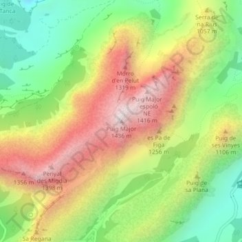
Топографическая карта Puig Major
Нажмите на карту, чтобы отобразить высоту.
Спасибо за поддержку этого сайта ❤️
Сделать пожертвование
Сделать пожертвование
Puig Major
Puig Major is the highest peak on the Spanish island of Majorca. With an elevation of 1,436 m (4,711 ft) above sea level. It is situated in the Serra de Tramuntana mountains. As the mountain is located in a military zone, the neighbouring peak Puig de Massanella (1,364 m) is considered the highest accessible summit on the island.
Спасибо за поддержку этого сайта ❤️
Сделать пожертвование
Сделать пожертвование
Об этой карте
Название: Топографическая карта Puig Major, высота, рельеф.
Местонахождение: Puig Major, Escorca, Serra de Tramuntana, Balearic Islands, Spain (39.80716 2.79404 39.80726 2.79414)
Средняя высота: 949 м
Минимальная высота: 510 м
Максимальная высота: 1 444 м
Спасибо за поддержку этого сайта ❤️
Сделать пожертвование
Сделать пожертвование