
Сделать пожертвование
Топографическая карта Salem
Нажмите на карту, чтобы отобразить высоту.
Сделать пожертвование
Salem
Salem is situated in the heart of the Willamette Valley and features a varied topography shaped by its proximity to notable geological formations. The city itself is primarily located at an elevation of around 177 feet (54 meters), but it spans a range from approximately 120 to 800 feet (37 to 244 meters) above sea level. To the west of Salem lie the Eola Hills, which rise to about 1,000 feet (300 meters), while the Waldo Hills to the east reach approximately 700 feet (210 meters). The southern parts of the city, including areas with canyons, are particularly hilly, contributing to the landscape's diversity. Additionally, the volcanic Salem Hills can be found in the southern region, enhancing the area's rugged charm. On clear days, residents and visitors can enjoy views of the Cascade Range, including iconic peaks like Mount Hood and Mount Jefferson, providing a picturesque backdrop to the city.
Сделать пожертвование
Об этой карте
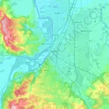
Название: Топографическая карта Salem, высота, рельеф.
Местонахождение: Salem, Marion County, Oregon, United States (44.85125 -123.12296 45.01662 -122.93521)
Средняя высота: 96 м
Минимальная высота: 30 м
Максимальная высота: 344 м
Сделать пожертвование
Другие топографические карты
Нажмите на карту, чтобы просмотреть ее топографию, ее высоту и ее рельеф.