
Сделать пожертвование
Топографическая карта Dimona
Нажмите на карту, чтобы отобразить высоту.
Сделать пожертвование
Dimona
Dimona is located in the Negev Desert. The city stands at an elevation of around 550–600 metres (1,800–1,970 ft) above sea level.
Сделать пожертвование
Об этой карте
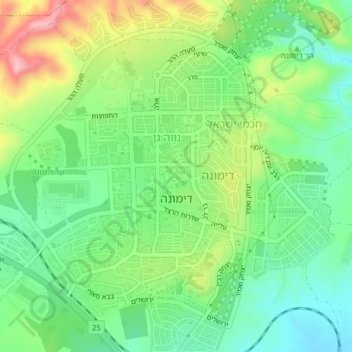
Название: Топографическая карта Dimona, высота, рельеф.
Местонахождение: Dimona, Beersheba Subdistrict, South District, Israel (31.05417 35.01951 31.08754 35.05418)
Средняя высота: 559 м
Минимальная высота: 497 м
Максимальная высота: 667 м
Сделать пожертвование
Другие топографические карты
Нажмите на карту, чтобы просмотреть ее топографию, ее высоту и ее рельеф.
Arad
The plan took into account topography and climate, with residential buildings constructed with large inner courtyards that offered protection from the desert sun and wind. High density residential areas were built first in order to create an urban milieu and shorten walking distances.
Средняя высота: 440 м
Сделать пожертвование
Сделать пожертвование
Сделать пожертвование