
Топографическая карта Great Skellig
Интерактивная карта
Нажмите на карту, чтобы отобразить высоту.
Об этой карте
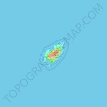
Название: Топографическая карта Great Skellig, высота, рельеф.
Местонахождение: Great Skellig, Kenmare Municipal District, County Kerry, Munster, Ireland (51.76784 -10.54505 51.77471 -10.53603)
Средняя высота: 1 м
Минимальная высота: 0 м
Максимальная высота: 161 м
Skellig Michael consists of approximately 22 hectares (54 acres) of rock, with its highest point, known as the Spit, 218 m (714 ft) above sea level. The island is defined by its twin peaks and intervening valley (known as Christ's Saddle), which make its landscape steep and inhospitable. It is best known for its Gaelic monastery, founded between the 6th and 8th centuries, and its variety of inhabiting species, which include gannets, puffins, a colony of razorbills and a population of approximately fifty grey seals. The island is of special interest to archaeologists, as the monastic settlement is in unusually good condition. The rock contains the remains of a tower house, a megalithic stone row and a cross-inscribed slab known as the Wailing Woman. The monastery is situated at an elevation of 170 to 180 m (550 to 600 ft), Christ's Saddle at 129 m (422 ft), and the flagstaff area at 37 m (120 ft) above sea level.
Другие топографические карты
Нажмите на карту, чтобы просмотреть ее топографию, ее высоту и ее рельеф.
Glencar
Glencar, Kenmare Municipal District, County Kerry, Munster, Ireland
Средняя высота: 114 м
Rathmore
Rathmore, Rathmore ED, Killarney Municipal District, County Kerry, Munster, P51 PT66, Ireland
Средняя высота: 149 м
Murreagh
Murreagh, Kenmare Municipal District, County Kerry, Munster, V92 P681, Ireland
Средняя высота: 37 м
Dooaghs
Dooaghs, Caragh ED, Kenmare Municipal District, County Kerry, Munster, Ireland
Средняя высота: 10 м
Castlegregory
Castlegregory, Kenmare Municipal District, County Kerry, Munster, V92 F6NX, Ireland
Средняя высота: 17 м
Kilgarvan
Kilgarvan, Kilgarvan ED, Kenmare Municipal District, County Kerry, Munster, Ireland
Средняя высота: 71 м
Fossa
Fossa, Killarney Rural ED, Killarney Municipal District, County Kerry, Munster, Ireland
Средняя высота: 42 м
Beaufort
Beaufort, Dunloe ED, Kenmare Municipal District, County Kerry, Munster, Ireland
Средняя высота: 38 м
Stradbally Mountain
Stradbally Mountain, Kenmare Municipal District, County Kerry, Munster, Ireland
Средняя высота: 487 м
Grenagh
Grenagh, Lahard ED, Killarney Municipal District, County Kerry, Munster, Ireland
Средняя высота: 36 м
Killarney
Killarney, Killarney Municipal District, County Kerry, Munster, Ireland
Средняя высота: 57 м
Kenmare Municipal District
Kenmare Municipal District, County Kerry, Munster, Ireland
Средняя высота: 98 м
Spunkane
Spunkane, Emlagh ED, Kenmare Municipal District, County Kerry, Munster, V23 HP11, Ireland
Средняя высота: 22 м
Glencloosagh Bay
Glencloosagh Bay, Tarbert ED, Listowel Municipal District, County Kerry, Munster, V31 WD66, Ireland
Средняя высота: 12 м
Brandon Mountain
Brandon Mountain, Kenmare Municipal District, County Kerry, Munster, Ireland
Средняя высота: 572 м
Dingle Peninsula
Dingle Peninsula, County Kerry, Munster, Ireland
Средняя высота: 75 м
Knockanure
Knockanure, Listowel Municipal District, County Kerry, Munster, Ireland
Средняя высота: 70 м
Carrauntoohil
Carrauntoohil, Kenmare Municipal District, County Kerry, Munster, V93 A8N1, Ireland
Средняя высота: 644 м
Kenmare
Ireland > County Kerry > Kenmare
Kenmare, Kenmare Municipal District, County Kerry, Munster, V93 KDX0, Ireland
Средняя высота: 87 м
Kilmorna
Kilmorna, Kilmeany ED, Listowel Municipal District, County Kerry, Munster, Ireland
Средняя высота: 65 м
Kilkeaveragh
Kilkeaveragh, Portmagee ED, Kenmare Municipal District, County Kerry, Munster, Ireland
Средняя высота: 38 м
Killorglin
Ireland > County Kerry > Killorglin
Killorglin, Kenmare Municipal District, County Kerry, Munster, V93 YD9D, Ireland
Средняя высота: 24 м
Brick
Brick, Drommartin ED, Listowel Municipal District, County Kerry, Munster, Ireland
Средняя высота: 4 м
Ardbeg
Ardbeg, Stradbally ED, Kenmare Municipal District, County Kerry, Munster, Ireland
Средняя высота: 33 м
Finuge
Finuge, Ennismore ED, Listowel Municipal District, County Kerry, Munster, Ireland
Средняя высота: 8 м
Rahoneen
Rahoneen, Banna ED, Tralee Municipal District, County Kerry, Munster, Ireland
Средняя высота: 9 м
Scartaglin
Ireland > County Kerry > Scartaglin
Scartaglin, Tralee Municipal District, County Kerry, Munster, Ireland
Средняя высота: 135 м
Rathmore
Ireland > County Kerry > Rathmore
Rathmore, Killarney Municipal District, County Kerry, Munster, Ireland
Средняя высота: 154 м
Duagh
Duagh, Duagh ED, Listowel Municipal District, County Kerry, Munster, Ireland
Средняя высота: 84 м
Dromclogh
Dromclogh, Ennismore ED, Listowel Municipal District, County Kerry, Munster, Ireland
Средняя высота: 41 м
Ballyduff
Ireland > County Kerry > Ballyduff
Ballyduff, Listowel Municipal District, County Kerry, Munster, Ireland
Средняя высота: 29 м
Killarney
Ireland > County Kerry > Killarney
Killarney, Killarney Municipal District, County Kerry, Munster, V93 AYP9, Ireland
Средняя высота: 66 м
Tralee Municipal District
Tralee Municipal District, County Kerry, Munster, Ireland
Средняя высота: 111 м
Dingle
Dingle, Kenmare Municipal District, County Kerry, Munster, Ireland
Средняя высота: 121 м
Mangerton
Mangerton, Kenmare Municipal District, County Kerry, Munster, V93 T250, Ireland
Средняя высота: 657 м