
Сделать пожертвование
Топографическая карта Surrey
Нажмите на карту, чтобы отобразить высоту.
Сделать пожертвование
Surrey
The highest elevation in Surrey is Leith Hill near Dorking. It is 295 m (968 ft) above sea level and is the second highest point in southeastern England after Walbury Hill in West Berkshire which is 297 m (974 ft).
Сделать пожертвование
Об этой карте
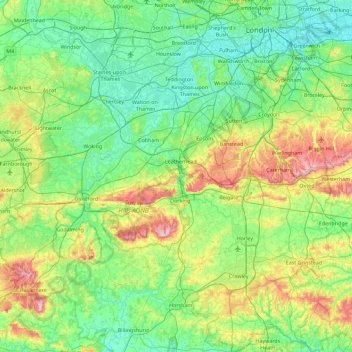
Название: Топографическая карта Surrey, высота, рельеф.
Местонахождение: Surrey, England, United Kingdom (51.07150 -0.84893 51.47156 0.05822)
Средняя высота: 69 м
Минимальная высота: -1 м
Максимальная высота: 289 м
Сделать пожертвование
Другие топографические карты
Нажмите на карту, чтобы просмотреть ее топографию, ее высоту и ее рельеф.
Camberley
United Kingdom > England > Surrey > Surrey Heath
The Staff College, to the north of Camberley town centre, is part of the Joint Services Command and Staff College, which provides training and education for established officers in the British Armed Forces and civil servants in the Ministry of Defence. The institution has its origins in the Royal Military…
Средняя высота: 88 м
Esher
United Kingdom > England > Surrey > Elmbridge
Esher is an outlying suburb of London near the London-Surrey Border, and with Esher Commons at its southern end, the town marks one limit of the Greater London Built-Up Area. Esher has a linear commercial high street and is otherwise suburban in density, with varying elevations, few high rise buildings and…
Средняя высота: 27 м