
Сделать пожертвование
Топографическая карта Tonopah
Нажмите на карту, чтобы отобразить высоту.
Сделать пожертвование
Tonopah
Tonopah has an arid, cold desert climate with cool winters and hot summers. Due to Tonopah’s aridity and high altitude, daily temperature ranges are quite large and lows in winter are similar to many continental climates. Nights are cool, even in summer.
Сделать пожертвование
Об этой карте
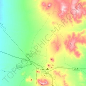
Название: Топографическая карта Tonopah, высота, рельеф.
Местонахождение: Tonopah, Nye County, Nevada, United States (38.04764 -117.31519 38.15231 -117.18605)
Средняя высота: 1 842 м
Минимальная высота: 1 649 м
Максимальная высота: 2 172 м
Сделать пожертвование
Другие топографические карты
Нажмите на карту, чтобы просмотреть ее топографию, ее высоту и ее рельеф.
Devils Hole
United States > Nevada > Nye County
Devils Hole is a geothermal pool within a limestone cavern in the Amargosa Desert in the Amargosa Valley of Nevada, east over the Amargosa Range and Funeral Mountains from Death Valley. It is at an elevation of 730 m (2,400 ft) above sea level and the water is a constant temperature of 33 °C (91 °F). The…
Средняя высота: 756 м
Amargosa Valley
United States > Nevada > Nye County
Amargosa Valley is located at 36.58001 North, 116.44487 West at an elevation of 2,640 feet (805 m) above sea level. The landscape is typical of lower to moderate elevations in the Mojave Desert, with flat expanses of sandy soil punctuated by rocky mounds and hills. Predominant indigenous vegetation is White…
Средняя высота: 740 м
Сделать пожертвование