
Топографическая карта Bella Vista
Интерактивная карта
Нажмите на карту, чтобы отобразить высоту.
Об этой карте
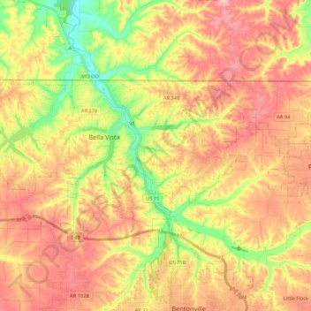
Название: Топографическая карта Bella Vista, высота, рельеф.
Местонахождение: Bella Vista, Benton County, Arkansas, 72715, United States of America (36.41540 -94.37571 36.49987 -94.16197)
Средняя высота: 374 м
Минимальная высота: 283 м
Максимальная высота: 448 м
The city of Bella Vista is located on the Springfield Plateau of the Ozark Mountains. Oak/hickory forests, along with valleys, creeks, and steep rises, characterize the city's topography. Bella Vista is located north of Bentonville and Rogers and is the northernmost Arkansas city in the Standard Metropolitan Statistical Area (which includes McDonald County, Missouri). The city has been experiencing a population and building boom in recent years, as indicated by a 60% growth in population between the 2000 and 2010 censuses.