
Топографическая карта City of London
Интерактивная карта
Нажмите на карту, чтобы отобразить высоту.
Об этой карте
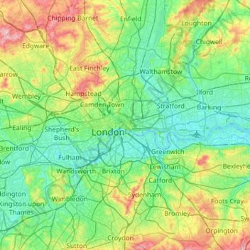
Название: Топографическая карта City of London, высота, рельеф.
Местонахождение: City of London, England, EC2V 5AE, United Kingdom (51.35562 -0.25200 51.67562 0.06800)
Средняя высота: 42 м
Минимальная высота: -3 м
Максимальная высота: 166 м
The elevation of the City ranges from sea level at the Thames to 21.6 metres (71 ft) at the junction of High Holborn and Chancery Lane. Two small but notable hills are within the historic core, Ludgate Hill to the west and Cornhill to the east. Between them ran the Walbrook, one of the many "lost" rivers or streams of London (another is the Fleet).
Другие топографические карты
Нажмите на карту, чтобы просмотреть ее топографию, ее высоту и ее рельеф.
The Fleet
United Kingdom > England > City of London > City of London
The Fleet, London Borough of Camden, City of London, Greater London, England, NW1 8NZ, United Kingdom
Средняя высота: 41 м