
Сделать пожертвование
Топографическая карта Payson
Нажмите на карту, чтобы отобразить высоту.
Сделать пожертвование
Payson
Located in northern Gila County at an elevation of 5,000 feet (1,500 m), the town has a total area of 19.5 square miles (51 km2). The Mogollon Rim, the southern boundary of the Colorado Plateau, lies to the north of Payson, with elevations exceeding 7,500 feet (2,300 m); there are many cold water lakes on top of the rim. They are stocked with fish by the Arizona Game and Fish Department.
Сделать пожертвование
Об этой карте
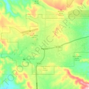
Название: Топографическая карта Payson, высота, рельеф.
Местонахождение: Payson, Gila County, Arizona, 85072, United States (34.21706 -111.37054 34.27176 -111.27319)
Средняя высота: 1 522 м
Минимальная высота: 1 379 м
Максимальная высота: 1 725 м
Сделать пожертвование
Другие топографические карты
Нажмите на карту, чтобы просмотреть ее топографию, ее высоту и ее рельеф.
Сделать пожертвование
Сделать пожертвование
Star Valley
United States > Arizona > Gila County > Star Valley
According to the United States Census Bureau, the town has a total area of 36.1 square miles (93.6 km2), of which 0.01 square miles (0.02 km2), or 0.03%, is water. Star Valley sits at an elevation of 4,650 feet (1,420 m) and takes its name from the valley in which it is located, formed by Houston Creek, which…
Средняя высота: 1 521 м
Сделать пожертвование