
Топографическая карта Salton Sea
Интерактивная карта
Нажмите на карту, чтобы отобразить высоту.
Об этой карте
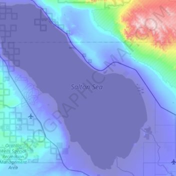
Название: Топографическая карта Salton Sea, высота, рельеф.
Средняя высота: 17 м
Минимальная высота: -73 м
Максимальная высота: 897 м
The lake occupies the lowest elevations of the Salton Sink in the Colorado Desert of Imperial and Riverside counties in Southern California. Its surface is 236.0 ft (71.9 m) below sea level as of January 2018. The deepest point of the sea is 5 ft (1.5 m) higher than the lowest point of Death Valley. The sea is fed by the New, Whitewater, and Alamo rivers, as well as agricultural runoff, drainage systems, and creeks.