
Сделать пожертвование
Топографическая карта Worcester
Нажмите на карту, чтобы отобразить высоту.
Сделать пожертвование
Об этой карте
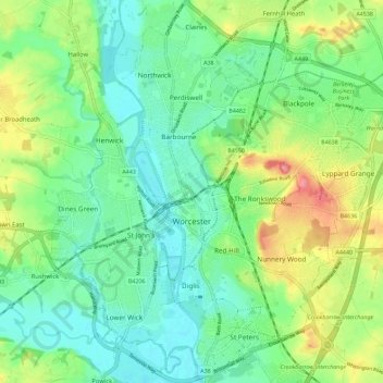
Название: Топографическая карта Worcester, высота, рельеф.
Местонахождение: Worcester, Worcestershire, England, United Kingdom (52.16164 -2.26321 52.23139 -2.15730)
Средняя высота: 38 м
Минимальная высота: 10 м
Максимальная высота: 96 м
Сделать пожертвование
Другие топографические карты
Нажмите на карту, чтобы просмотреть ее топографию, ее высоту и ее рельеф.
Lickey Hills Country Park
United Kingdom > England > Worcestershire > Bromsgrove > Cofton Hackett CP
Средняя высота: 209 м
Upper Broadheath
United Kingdom > England > Worcestershire > Malvern Hills > Crown East
Средняя высота: 44 м
Сделать пожертвование
Сделать пожертвование
Morton Stanley Park
United Kingdom > England > Worcestershire > Redditch > Callow Hill
Средняя высота: 129 м
Сделать пожертвование
Stourport Historic Canal Basins
United Kingdom > England > Worcestershire > Wyre Forest > Stourport-on-Severn > Wilden
Средняя высота: 33 м
Сделать пожертвование
Сделать пожертвование
Malvern
United Kingdom > England > Worcestershire > Malvern Hills
Malvern lies in the Lower Severn/Avon plain affording it a degree of shelter caused by virtue of its nestling in between the Cotswold hills to the east, the Welsh Hills and Mountains to the west, and Birmingham plateau to the north. Although as with all the British Isles it has a maritime climate, the local…
Средняя высота: 95 м
Сделать пожертвование
River Severn
United Kingdom > England > Worcestershire > Wyre Forest > Stourport-on-Severn
Средняя высота: 45 м
Сделать пожертвование
Lickey Hills Country Park
United Kingdom > England > Worcestershire > Birmingham > Rednal
Средняя высота: 226 м
Upper Wick
United Kingdom > England > Worcestershire > Malvern Hills District > Rushwick > Upper Wick
Средняя высота: 30 м
Сделать пожертвование
Сделать пожертвование
Сделать пожертвование
Upper Welland
United Kingdom > England > Worcestershire
Upper Welland is a small settled area within the civil parish of Malvern Wells, in Worcestershire, England. Lying close to the county boundaries of Herefordshire.It was formed when the upper part of Welland parish joined the newly created Malvern Hills Urban District. Welland Parish once stretched to the ridge…
Средняя высота: 115 м
Corse Lawn
United Kingdom > England > Worcestershire > Malvern Hills > Eldersfield
Средняя высота: 26 м
Shatterford
United Kingdom > England > Worcestershire > Wyre Forest > Upper Arley
Средняя высота: 124 м
Tanner's Green
United Kingdom > England > Worcestershire > Bromsgrove > Wythall CP
Средняя высота: 158 м
Сделать пожертвование
Beacon Wood
United Kingdom > England > Worcestershire > Bromsgrove > Lydiate Ash
Средняя высота: 210 м
Major's Green
United Kingdom > England > Worcestershire > Bromsgrove > Wythall CP
Средняя высота: 146 м
Сделать пожертвование
The Hill, Abberley
United Kingdom > England > Worcestershire > Malvern Hills > Abberley
Средняя высота: 132 м
Ronkswood Hill Meadows Local Nature Reserve
United Kingdom > England > Worcestershire > Worcester
Средняя высота: 56 м
Сделать пожертвование
Badsey Lane Nature Reserve
United Kingdom > England > Worcestershire > Wychavon > Evesham
Средняя высота: 37 м
Сделать пожертвование
Сделать пожертвование
Сделать пожертвование
Table Hill
United Kingdom > England > Worcestershire > Malvern Hills
Table Hill is situated in the range of Malvern Hills that runs about 13 kilometres (8 mi) north-south along the Herefordshire-Worcestershire border. It lies between North Hill and Sugarloaf Hill and has an elevation of 373 metres (1,224 ft).
Средняя высота: 188 м
Сделать пожертвование
Сделать пожертвование
Сделать пожертвование
Сделать пожертвование
Сделать пожертвование
Menithwood
United Kingdom > England > Worcestershire > Malvern Hills District > Menithwood
Средняя высота: 122 м
Сделать пожертвование
Foley Park
United Kingdom > England > Worcestershire > Wyre Forest District > Foley Park
Средняя высота: 55 м
Сделать пожертвование
Malvern
United Kingdom > England > Worcestershire > Malvern Hills
Malvern lies in the Lower Severn/Avon plain affording it a degree of shelter caused by virtue of its nestling in between the Cotswold hills to the east, the Welsh Hills and Mountains to the west, and Birmingham plateau to the north. Although as with all the British Isles it has a maritime climate, the local…
Средняя высота: 95 м
Сделать пожертвование