
Топографическая карта Johns Creek
Интерактивная карта
Нажмите на карту, чтобы отобразить высоту.
Об этой карте
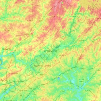
Название: Топографическая карта Johns Creek, высота, рельеф.
Местонахождение: Johns Creek, Georgia, 30097, United States of America (33.85816 -84.35020 34.17816 -84.03020)
Средняя высота: 314 м
Минимальная высота: 253 м
Максимальная высота: 402 м
Johns Creek is located in northeastern Fulton County and is centered at 34°1′44″N 84°11′55″W / 34.02889°N 84.19861°W / 34.02889; -84.19861 (34.0289259, -84.1985790). The elevation ranges from 880 feet (270 m) above sea level along the Chattahoochee River to 1,180 feet (360 m) in the Ocee area along the Alpharetta border. Johns Creek is bounded to the south by the Chattahoochee River and Gwinnett County, and on the northeast by McGinnis Ferry Road and Forsyth County. It is bounded by Roswell to the west, Alpharetta to the northwest, Suwanee to the east, and Duluth, Berkeley Lake, and Peachtree Corners to the south. Downtown Atlanta is 27 miles (43 km) to the southwest.