
Сделать пожертвование
Топографическая карта Central Park
Нажмите на карту, чтобы отобразить высоту.
Сделать пожертвование
Central Park
In June 1856, Fernando Wood appointed a "consulting board" of seven people, headed by author Washington Irving, to inspire public confidence in the proposed development. Wood hired military engineer Egbert Ludovicus Viele as the park's chief engineer, tasking him with a topographical survey of the site. The following April, the state legislature passed a bill to authorize the appointment of four Democratic and seven Republican commissioners, who had exclusive control over the planning and construction process. Though Viele had already devised a plan for the park, the commissioners disregarded it and retained him to complete only the topographical surveys. The Central Park Commission began hosting a landscape design contest shortly after its creation. The commission specified that each entry contain extremely detailed specifications, as mandated by the consulting board. Thirty-three firms or organizations submitted plans.
Сделать пожертвование
Об этой карте
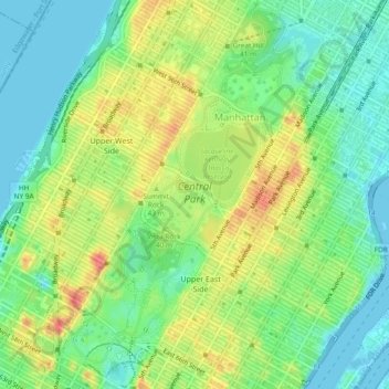
Название: Топографическая карта Central Park, высота, рельеф.
Местонахождение: Central Park, New York County, New York, 11025, United States (40.76473 -73.98141 40.80031 -73.94961)
Средняя высота: 26 м
Минимальная высота: -5 м
Максимальная высота: 65 м
Сделать пожертвование
Другие топографические карты
Нажмите на карту, чтобы просмотреть ее топографию, ее высоту и ее рельеф.
Manhattan
United States > New York > New York County > New York
Manhattan, a densely populated urban island, has a diverse topography characterized by its generally flat terrain interspersed with elevated areas. The average elevation is about 50 feet (15 meters) above sea level, with its highest point reaching approximately 265 feet (81 meters) at Bennett Park in…
Средняя высота: 16 м
Manhattan
United States > New York > New York County > New York
Marble Hill is one example of how Manhattan's land has been considerably altered by human intervention. The borough has seen substantial land reclamation along its waterfronts since Dutch colonial times, and much of the natural variation in its topography has been evened out.
Средняя высота: 16 м
Manhattan
United States > New York > New York County > New York
Parkland covers a total of 2,659 acres (10.76 km2), accounting for 18.2% of the borough's land area; the 840-acre (3.4 km2) Central Park is the borough's largest park, comprising 31.6% of Manhattan's parkland. Designed by Frederick Law Olmsted and Calvert Vaux, the park is anchored by the 12-acre (4.9 ha)…
Средняя высота: 16 м
Roosevelt Island
United States > New York > New York County > New York
The island is one of the southernmost locations in New York City where Fordham gneiss, a type of bedrock commonly found beneath the South Bronx, can be seen above ground. The gneiss outcropping was surrounded by dolomite, which was worn down by East River currents, creating the current island. The layer of…
Средняя высота: 13 м
Сделать пожертвование
Governors Island
United States > New York > New York County > New York
By the mid-1790s, increased military tensions renewed an interest in fortifying New York Harbor, and a U.S. congressional committee had drawn a map of possible locations for the First System of fortifications to protect major American urban centers. Governors Island was one of the first locations where…
Средняя высота: 1 м
Manhattan Community Board 12
United States > New York > New York County > New York
Средняя высота: 31 м
Governors Island
United States > New York > New York County > New York
By the mid-1790s, increased military tensions renewed an interest in fortifying New York Harbor, and a U.S. congressional committee had drawn a map of possible locations for the First System of fortifications to protect major American urban centers. Governors Island was one of the first locations where…
Средняя высота: 1 м
Сделать пожертвование
Manhattan
United States > New York > New York County > New York
Parkland covers a total of 2,659 acres (10.76 km2), accounting for 18.2% of the borough's land area; the 840-acre (3.4 km2) Central Park is the borough's largest park, comprising 31.6% of Manhattan's parkland. Designed by Frederick Law Olmsted and Calvert Vaux, the park is anchored by the 12-acre (4.9 ha)…
Средняя высота: 16 м
Сделать пожертвование
Roosevelt Island
United States > New York > New York County > New York
The island is one of the southernmost locations in New York City where Fordham gneiss, a type of bedrock commonly found beneath the South Bronx, can be seen above ground. The gneiss outcropping was surrounded by dolomite, which was worn down by East River currents, creating the current island. The layer of…
Средняя высота: 13 м
Manhattan
United States > New York > New York County > New York
Parkland covers a total of 2,659 acres (10.76 km2), accounting for 18.2% of the borough's land area; the 840-acre (3.4 km2) Central Park is the borough's largest park, comprising 31.6% of Manhattan's parkland. Designed by Frederick Law Olmsted and Calvert Vaux, the park is anchored by the 12-acre (4.9 ha)…
Средняя высота: 16 м
Сделать пожертвование
Highbridge Park
United States > New York > New York County > New York
The north and south wings respectively contain the women's and men's locker rooms and are nearly identical. Both have nine windows separated by eight brick pilasters. The stone capitals of the pilasters line up with the lintels of the windows. Ramps lead from the extreme ends of each wing. The ground slopes…
Средняя высота: 30 м
Manhattan
United States > New York > New York County > New York
Marble Hill is one example of how Manhattan's land has been considerably altered by human intervention. The borough has seen substantial land reclamation along its waterfronts since Dutch colonial times, and much of the natural variation in its topography has been evened out.
Средняя высота: 16 м
Manhattan
United States > New York > New York County > New York
Parkland covers a total of 2,659 acres (10.76 km2), accounting for 18.2% of the borough's land area; the 840-acre (3.4 km2) Central Park is the borough's largest park, comprising 31.6% of Manhattan's parkland. Designed by Frederick Law Olmsted and Calvert Vaux, the park is anchored by the 12-acre (4.9 ha)…
Средняя высота: 16 м