
Сделать пожертвование
Топографическая карта Ayungon
Нажмите на карту, чтобы отобразить высоту.
Сделать пожертвование
Об этой карте
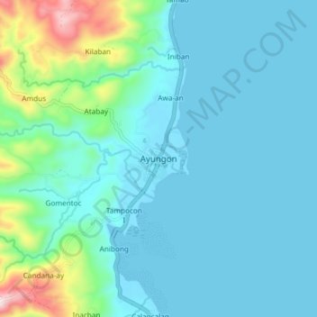
Название: Топографическая карта Ayungon, высота, рельеф.
Местонахождение: Ayungon, Negros Oriental, Negros Island Region, 6210, Philippines (9.81842 123.10352 9.89842 123.18352)
Средняя высота: 93 м
Минимальная высота: -1 м
Максимальная высота: 607 м
Сделать пожертвование
Другие топографические карты
Нажмите на карту, чтобы просмотреть ее топографию, ее высоту и ее рельеф.
Pamplona
Mountain ridges overlooking the plains of Pamplona, can be an object for viewers of scenic beauties. Nabalabag ridge, located at an elevation of 800 m above sea level at barangay San Isidro, overlooks on the west at municipalities of Bayawan and Santa Catalina and in the east, with the town of Pamplona, Tanjay…
Средняя высота: 342 м
Сделать пожертвование
Valencia
Valencia occupies an area of 14,749 hectares (36,450 acres), 35% of which are classified as plains. The town is 65% mountainous, with elevation averaging from 200 to 500 metres (660 to 1,640 ft) above sea level, with the top of Mount Talinis at an elevation of 1,903 metres (6,243 ft) along the municipal…
Средняя высота: 367 м
Dumaguete
As a coastal city, it is bounded on the east by the Bohol Sea and the Tañon Strait, serving as a natural border of southeastern Negros Island Region to the neighboring Central Visayas. The city's topography is generally flat from two to six kilometers from the shoreline. It slopes gently upwards to the…
Средняя высота: 56 м
Сделать пожертвование
Santa Catalina
The topography of Santa Catalina is predominantly slightly rolling hills (70% of its area), 25% is flat, and the remainder is steep terrain. There are 8 rivers and 27 springs.
Средняя высота: 142 м
Сделать пожертвование
Сделать пожертвование
Сделать пожертвование
Сделать пожертвование
Сделать пожертвование
Сделать пожертвование
Сделать пожертвование
Сделать пожертвование
Pamplona
Mountain ridges overlooking the plains of Pamplona, can be an object for viewers of scenic beauties. Nabalabag ridge, located at an elevation of 800 m above sea level at barangay San Isidro, overlooks on the west at municipalities of Bayawan and Santa Catalina and in the east, with the town of Pamplona, Tanjay…
Средняя высота: 339 м
Сделать пожертвование
Сделать пожертвование
Valencia
Valencia occupies an area of 14,749 hectares (36,450 acres), 35% of which are classified as plains. The town is 65% mountainous, with elevation averaging from 200 to 500 metres (660 to 1,640 ft) above sea level, with the top of Mount Talinis at an elevation of 1,903 metres (6,243 ft) along the municipal…
Средняя высота: 367 м
Сделать пожертвование
Сделать пожертвование
Santa Catalina
The topography of Santa Catalina is predominantly slightly rolling hills (70% of its area), 25% is flat, and the remainder is steep terrain. There are 8 rivers and 27 springs. Santa Catalina is 94 kilometres (58 mi) from Dumaguete.
Средняя высота: 142 м
Сделать пожертвование
Dumaguete
As a coastal city, it is bounded on the east by the Bohol Sea and the Tañon Strait, serving as a natural border of southeastern Negros Island Region to the neighboring Central Visayas. The city's topography is generally flat from two to six kilometers from the shoreline. It slopes gently upwards to the…
Средняя высота: 56 м
Dumaguete
As a coastal city, it is bounded on the east by the Bohol Sea and the Tañon Strait, serving as a natural border of the southeastern border of Negros Oriental. The city's topography is generally flat from two to six kilometers from the shoreline. It slopes gently upwards to the adjoining municipality of…
Средняя высота: 56 м
Valencia
Valencia occupies an area of 14,749 hectares (36,450 acres), 35% of which are classified as plains. The town is 65% mountainous, with elevation averaging from 200 to 500 metres (660 to 1,640 ft) above sea level, with the top of Mount Talinis at an elevation of 1,903 metres (6,243 ft) along the municipal…
Средняя высота: 367 м
Сделать пожертвование
Dumaguete
As a coastal city, it is bounded on the east by the Bohol Sea and the Tañon Strait, serving as a natural border of southeastern Negros Island Region to the neighboring Central Visayas. The city's topography is generally flat from two to six kilometers from the shoreline. It slopes gently upwards to the…
Средняя высота: 56 м