
Сделать пожертвование
Топографическая карта Abbess Roding
Нажмите на карту, чтобы отобразить высоту.
Сделать пожертвование
Об этой карте
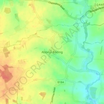
Название: Топографическая карта Abbess Roding, высота, рельеф.
Местонахождение: Abbess Roding, Epping Forest, Essex, England, CM5 0PA, United Kingdom (51.75894 0.25740 51.79894 0.29740)
Средняя высота: 73 м
Минимальная высота: 52 м
Максимальная высота: 95 м
Сделать пожертвование
Другие топографические карты
Нажмите на карту, чтобы просмотреть ее топографию, ее высоту и ее рельеф.
Connaught Water
United Kingdom > England > Essex > Epping Forest > Sewardstonebury
Средняя высота: 57 м
Epping Forest
United Kingdom > England > Essex > Epping Forest > Debden Green
It lies on a ridge between the valleys of the rivers Lea and Roding. It contains areas of woodland, grassland, heath, streams, bogs and ponds, and its elevation and thin gravelly soil (the result of glaciation) historically made it less suitable for agriculture. The Forest was historically managed as a common;…
Средняя высота: 44 м
Сделать пожертвование
Roughtalley's Wood (South) & Epping Forest Woodland Burial Ground
United Kingdom > England > Essex > Epping Forest > Coopersale
Средняя высота: 96 м
Сделать пожертвование
Stanford Rivers
United Kingdom > England > Essex > Epping Forest > Stanford Rivers
Средняя высота: 65 м
Сделать пожертвование
Epping Forest
United Kingdom > England > Essex > Epping Forest > Debden Green
It lies on a ridge between the valleys of the rivers Lea and Roding. It contains areas of woodland, grassland, heath, streams, bogs, and ponds, and its elevation and thin gravelly soil (the result of glaciation) historically made it less suitable for agriculture. The forest was historically managed as a…
Средняя высота: 44 м
Сделать пожертвование
Epping Forest
United Kingdom > England > Essex > Epping Forest
It lies on a ridge between the valleys of the rivers Lea and Roding. It contains areas of woodland, grassland, heath, streams, bogs, and ponds, and its elevation and thin gravelly soil (the result of glaciation) historically made it less suitable for agriculture. The forest was historically managed as a…
Средняя высота: 44 м