
Сделать пожертвование
Топографическая карта Ashover CP
Нажмите на карту, чтобы отобразить высоту.
Сделать пожертвование
Ashover CP
By the 18th century, there were several thousand acres of unenclosed moorland in the parish of Ashover, principally covered with heath. The only paths across this wilderness for roads were tracks in the sand or heath with here and there a stone post on the hills or elevations to serve as guides to the traveller and packhorses which traversed one point of the area to another.
Сделать пожертвование
Об этой карте
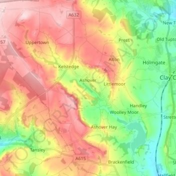
Название: Топографическая карта Ashover CP, высота, рельеф.
Местонахождение: Ashover CP, Kelstedge, North East Derbyshire, Derbyshire, England, United Kingdom (53.11972 -1.55303 53.20107 -1.44389)
Средняя высота: 210 м
Минимальная высота: 91 м
Максимальная высота: 334 м
Сделать пожертвование
Другие топографические карты
Нажмите на карту, чтобы просмотреть ее топографию, ее высоту и ее рельеф.